

Bio
Dr. Md. Rafi Uddin was born in Sirajganj, Bangladesh on 14 August 1974. He earned his B. Sc. (Honours) degree in Physics in 1995 (examination held in 1997) and M. Sc. degree in Physics in 1996 (examination held in 1999) from Jahangirnagar University, Savar, Dhaka, Bangladesh. He completed his M. Phil. degree in Physics from Bangladesh University of Engineering and Technology (BUET), Dhaka, in 2003. He joined the Department of Physics, BUET, Dhaka, as a Lecturer in August 2002. He was promoted to Assistant Professor in February 2006, Associate Professor in July 2012, and Professor in February 2015. He received his Ph. D. degree from the Department of Earth and Environmental Sciences, Nagoya University, Japan, in September 2009 in the field of Meteorology. Dr. Uddin has supervised so far 03 M. Sc., 05 M. Phil., and 01 Ph. D. students. He has participated in 16 training workshops or courses and has presented his research work at different conferences and workshops at home and abroad. Dr. Uddin has published book chapters, more than 26 peer-reviewed scientific articles, 42 proceedings. Additionally, he has completed 06 research projects. He is actively involved in collaborative research work with the Universities in Japan and Australia. His present research interests are Monsoon Meteorology, Remote Sensing, Mesoscale Modeling, Lightning and Climate Change.
For more information, please visit personal website: http://rafiuddin.buet.ac.bd/
Education & Training
-
Ph. D. 2009
Meteorology
Nagoya University, Japan
-
M. Phil. 2003
Physics
Bangladesh University of Engineering and Technology (BUET)
-
M. Sc. in Physics 1996 (held in 1999)
Physics
Jahangirnagar University, Savar, Dhaka
-
B. Sc. in Physics 1995 (held in 1997)
Physics
Jahangirnagar University, Savar, Dhaka
Honors, Awards and Grants
-
29 May - 09 June 2006Grants for Third ICTP Workshop on the Theory and Use of Regional Climate Models, 29 May - 9 June 2006, ICTP, Trieste, Italy.

Grants for Third ICTP Workshop on the Theory and Use of Regional Climate Models, 29 May - 9 June 2006, ICTP, Trieste, Italy.
-
28 October - 01 November 2013Grants for the 5th International Workshop on Monsoons (IWM-V), 28 October - 01 November 2013, Macao, China, 2013.
Grants for the 5th International Workshop on Monsoons (IWM-V), 28 October - 01 November 2013, Macao, China, 2013.
-
27-29 November 2013Grants for the 2nd International Conference on Southeast Asian Weather and Climate (ICSA-WC2013), 27-29 November 2013, Chiang Mai, Thailand, 2013.
Grants for the 2nd International Conference on Southeast Asian Weather and Climate (ICSA-WC2013), 27-29 November 2013, Chiang Mai, Thailand, 2013.
-
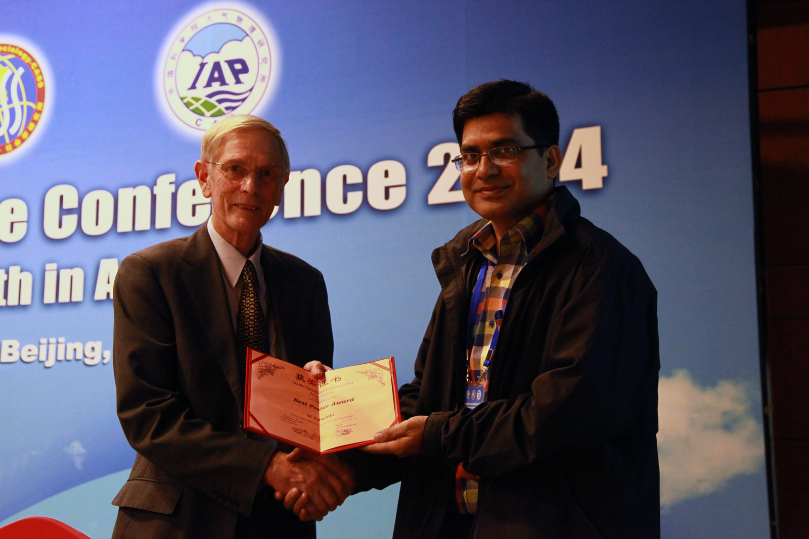
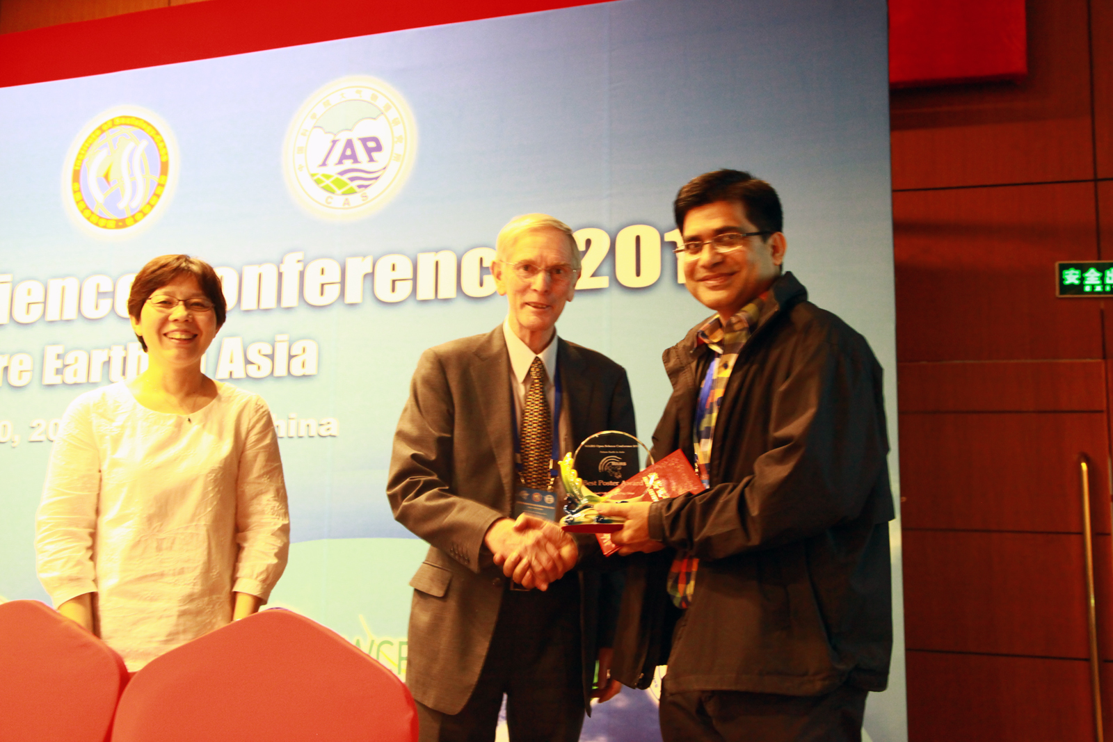
2014Best Poster Award
Monsoon Asia Integrated Regional Studies (MAIRS) Open Science Conference (MAIRS-OSC2014), China
-
2006-2009Monbukagakusho Scholarship
MEXT Scholarship for PhD
-
20-24 October 2013Grants for the 34th Asian Conference on Remote Sensing (ACRS-2013), 20 -24 October 2013, Bali Island, Indonesia, 2013.
Grants for the 34th Asian Conference on Remote Sensing (ACRS-2013), 20 -24 October 2013, Bali Island, Indonesia, 2013.
-
1992-1996Merit Scholarship
University of Jahangirnagar, Savar, Dhaka
-
19-23 August 2013Grants for INEES Final Workshop, 19-23 August 2013, Flensburg, Germany.
Grants for INEES Final Workshop, Organized by the University of Flensburg and International Network for Energy & Environmental Sustainability (INEES), University of Flensburg, 19-23 August 2013, Flensburg, Germany.
-
19-21 November 2008Grants for Autumn Meeting of the Meteorological Society of Japan, 19-21 November 2008, Sendai, Japan.
Grants for Autumn Meeting of the Meteorological Society of Japan, 19-21 November 2008, Sendai, Japan.
-
17-19 November 2014Grants for new and emerging remote sensing technologies for precipitation data sets and their applications and validation, Tsukuba, Japan.
Grants for new and emerging remote sensing technologies for precipitation data sets and their applications and validation, Organized by the International Precipitation Working Group (IPWG) and Japan Aerospace Exploration Agency (JAXA), 17-19 November 2014, Tsukuba, Japan.
-
15-18 July 2024Grants for the 11th Workshop of International Precipitation Working Group (IPWG-11), 15-18 July 2024, Tokyo Institute of Technology, Tokyo, Japan, 2024.
Grants for the 11th Workshop of International Precipitation Working Group (IPWG-11), 15-18 July 2024, Tokyo Institute of Technology, Tokyo, Japan, 2024.
-
14-27 August 2005Grants for 2nd KAGI21 International Summer School, 14-27 August 2005, ITB, Bandung, Indonesia.
Grants for 2nd KAGI21 International Summer School, Organized by Faculty of Earth Sciences and Mineral Technology, Institut Teknologi Bandung (FIKTM-ITM) and Kyoto University Active Geosphere Investigations for the 21st Century COE program (KAGI21), 14-27 August 2005, ITB, Bandung, Indonesia.
-
14-16 October 2007Grants for Autumn Meeting of the Meteorological Society of Japan, 14-16 October 2007, Sapporo, Japan.
Grants for Autumn Meeting of the Meteorological Society of Japan, 14-16 October 2007, Sapporo, Japan.
-
13-17 February 2012Grants for INEES Science Education-III, Flensburg, Germany.
Grants for INEES Science Education-III, Organized by the University of Flensburg and International Network for Energy & Environmental Sustainability (INEES), University of Flensburg, 13-17 February 2012, Flensburg, Germany.
-
13-16 November 2012Grants for the 4th TRMM and GPM International Science Conference, 13-16 November 2012, Tokyo, Japan, 2012.
Grants for the 4th TRMM and GPM International Science Conference, 13-16 November 2012, Tokyo, Japan, 2012.
-
13-16 May 2007Grants for spring Meeting of the Meteorological Society of Japan, 13-16 May 2007, Tokyo, Japan.
Grants for spring Meeting of the Meteorological Society of Japan, 13-16 May 2007, Tokyo, Japan.
-
07-12 July 2024Grants for the 9th Global Energy and Water Exchanges Open Science Conference (GEWEX OSC), 07-12 July 2024, Sapporo, Japan, 2024.
Grants for the 9th Global Energy and Water Exchanges Open Science Conference (GEWEX OSC), 07-12 July 2024, Sapporo, Japan, 2024.
-
07-10 April 2014Grants for the Monsoon Asia Integrated Regional Studies (MAIRS) Open Science Conference (MAIRS-OSC2014), 07-10 April 2014, Beijing, China, 2014.
Grants for the Monsoon Asia Integrated Regional Studies (MAIRS) Open Science Conference (MAIRS-OSC2014), 07-10 April 2014, Beijing, China, 2014.
-
07 December 2011Grants for the 3rd GPM Asia Workshop on Precipitation Data Application Technique, Tokyo, Japan, December 7, 2011.
Grants for the 3rd GPM Asia Workshop on Precipitation Data Application Technique, Tokyo, Japan, December 7, 2011.
-
06-09 November 2007Grants for the 6th International Conference on Mesoscale Meteorology and Typhoon in East Asia (ICMCS-VI), 6-9 November 2007, Taipei, Taiwan.
Grants for the 6th International Conference on Mesoscale Meteorology and Typhoon in East Asia (ICMCS-VI), 6-9 November 2007, Taipei, Taiwan.
-
03-15 November 2008Grants for Satellite Remote Sensing of Atmospheric Constituents Training Workshop, Japan
Grants for Satellite Remote Sensing of Atmospheric Constituents, Organized by Water Science Unit of UNESCO Office Jakarta and the Institute of Hydrospheric Atmospheric Sciences of Nagoya University, 3-15 November 2008, Nagoya, Japan.
-
03-09 October 2010Grants for INEES Science Education, Jamaica.
Grants for INEES Science Education, Organized by the University of the West Indies and International Network for Energy & Environmental Sustainability (INEES), University of Flensburg, 03-09 October 2010, Jamaica.
-
02-15 December 2007Grants for Numerical Prediction of High-Impact Weather Systems Training Workshop, Japan
Grants for Numerical Prediction of High-Impact Weather Systems, Organized by Water Science Unit of UNESCO Office Jakarta and the Institute of Hydrospheric Atmospheric Sciences of Nagoya University, 2-15 December 2007, Nagoya, Japan.
-
01-03 April 2011Grants for International Conference on Environment Science and Engineering (ICESE 2011), Bali Island, Indonesia, 1-3 April, 2011.
Grants for International Conference on Environment Science and Engineering (ICESE 2011), Bali Island, Indonesia, 1-3 April, 2011.
Publications
Filter by type:
Sort by year:
Role of pollutants on the bimodal lightning distribution in Bangladesh
Abstract
The impact of atmospheric pollutants on lightning activity is an evolving issue. This study investigates the relationship between various pollutants and lightning occurrences in Bangladesh, a country that is frequently affected by extreme weather events. Using six years of cloud-to-ground lightning records (2015–2020) from Vaisala’s Global Lightning Dataset and pollutants data, including aerosols, particulate matter (PM1, PM2.5, and PM10), and other compounds from the ECMWF Atmospheric Composition Reanalysis 4, the study explores interactions between lightning and pollutions in detail. Over the study period, 754 lightning days and 1,438 non-lightning days were documented, with the highest stroke count of 817,547, observed on 5 April 2016. Lightning activity exhibited a bimodal distribution, with the primary peak in April-May and a secondary peak in August-September. The winter months (December-January) experienced the least lightning activity. The highest concentrations of DUST, SO4, and O3 coincided with the primary peak, revealing significant positive correlations (r = 0.7, 0.6, and 0.6, respectively) at the 99% confidence level. In contrast, PM1, PM2.5, and PM10 concentrations peaked in winter and showed moderately negative correlations (- 0.5) with lightning. A comparative analysis reveals that DUST and SO4 concentrations during the primary lightning peak were 88% and 51% higher than in the secondary peak. These findings suggest that the transportation of large amounts of DUST and SO4 by strong upper-level westerlies in April-May, and smaller amounts by low-level southwesterlies in August-September, significantly influences the observed bimodal distribution of lightning activity in Bangladesh, potentially through modifications in thundercloud dynamics.
Pre-monsoon lightning in Bangladesh: Separating most from least active days with thermodynamic and synoptic composites
Abstract
The pre-monsoon season (March–May) in Bangladesh is the most hazardous period for lightning-related human casualties, particularly during morning and afternoon hours. This heightened risk is primarily associated with labor-intensive manual agriculture on smallholder farms. This study investigates the atmospheric conditions corresponding to the 50 most active and 50 least active pre-monsoon lightning days between 2015 and 2020. Analysis of sounding and reanalysis data reveals distinct differences across nearly all dynamic, thermodynamic, surface, and upper-air composite parameters. On the most active lightning days, the environment typically features a SWEAT index exceeding 230, a mixed-layer mixing ratio above 15 g kg−1, and high values of the most unstable convective available potential energy (≥1580 J kg−1), along with elevated instability—all conducive to thunderstorms with heavy rainfall. Notably, on 20 % of these active days, storm-relative environmental helicity reaches between 300 and 485 m2 s−2, indicating a high potential for supercell thunderstorms and intense lightning activity. In contrast, the least-active lightning days are characterized by weaker storm systems. These variations are primarily driven by strong, warm, moist southwesterly winds from the Bay of Bengal, which enhance horizontal temperature gradients and atmospheric instability. Regression models identified potential instability, cloud ice water content, and cloud liquid water content as strong synoptic-scale predictors of lightning activity. Principal component analysis (PCA) further highlighted the critical role of cloud-scale thermodynamic and kinematic variables in distinguishing lightning intensity. These findings provide a foundation for developing daily lightning forecast systems, with potential benefits for public safety and protection of lightning-sensitive infrastructure.
Outbreak of a tornado with tropical cyclone Yaas (2021) formed over the Bay of Bengal
Abstract
A tornado outbreak occurred in West Bengal (WB), India, about 15–16 h before the landfall of Cyclone Yaas formed in May 2021 over the Bay of Bengal. High-resolution analysis data have been used to investigate the possible tornadoes in terms of environmental conditions connecting to the cyclone. The WB tornado is found as intense as EF2–3 on the tornado scale and is likely associated with a mini-supercell. The total shear of 37 m s-1 from 0–6 km above ground level (AGL) with strong clockwise rotation, the moderate instability (1504 J kg-1) and the energy helicity index of 2.2 are the substantial convective parameters related to the WB tornado. Moreover, the favorable environment owning intense bulk shear, a larger value of storm-relative environmental helicity in the lowest 1 km AGL and high values of significant tornado parameter (STP) urge the potentiality of multiple tornadoes spawning in multi-days accompanying the landfalling Cyclone Yaas. The right-front quadrant of the cyclone is found to be more vulnerable for developing moderate to severe tornadoes within its rainbands. The positive potential vorticity anomalies evidence the cloud-scale cyclonic circulation from surface to 400 hPa with the maximum in the mid-level.
Comparison of diurnal variation of rainfall of GSMaP and rain gauge data in Bangladesh
Abstract
The diurnal variation of rainfall across Bangladesh is evaluated using data from the Global Satellite Mapping of Precipitation (GSMaP). GSMaP data has a temporal resolution of 1 hour and a spatial precision of 0.1 degree. GSMaP data is combined with three hourly rain gauge data from 35 sites of Bangladesh Meteorological Department (BMD). The diurnal variation of rainfall and their spatial distribution are compared in daily, monthly and yearly scales during the period of 2001-2015. It is observed that GSMaP data is well correlated with BMD rain gauge data. The correlation coefficients between GSMaP and BMD rain gauge for 3-hourly, daily, monthly and yearly rainfall are found 0.71, 0.74, 0.82 and 0.66, respectively. The GSMaP measured daily maximum rainfall over Bangladesh at 0300 LST (Local Standard Time) with a secondary maximum peak at 1500 LST, whereas, rain gauge got primary peak at 0600 LST with a secondary peak at 1500 LST. The diurnal variation of rainfall observed by GSMaP is well matched with rain gauge observation during the pre-monsoon, post-monsoon and winter season. During monsoon season, the primary peak of rainfall is measured at 1500 LST by GSMaP whereas rain gauge is found at 0600 LST. The maximum rainfall is found in the southern, western, eastern and central regions of the country during 1200-1500 LST. In the southeastern region of Bangladesh the maximum rainfall is found during 0600-0900 LST. The maximum rainfall is observed in the northwestern and northeastern regions of the country during 0300-0600 LST.
Extreme temperature and rainfall events in Bangladesh: a comparison between coastal and inland areas
Abstract
Although coastal and inland areas of Bangladesh exhibit distinct physiographic and climatic characteristics, spatiotemporal variation of extreme climatic events are poorly understood in these two areas. This study was an attempt to understand the trends in extreme climatic events in coastal and inland areas over the period 1968‐2018. The missing data in daily maximum and minimum temperature, and daily rainfall datasets were imputed using the multiple imputation by chained equations (MICE) technique and implementing a predictive mean matching algorithm. The imputed datasets were then tested for inhomogeneity using the penalized maximal t (PMT) and modified penalized maximal F (PMF) tests. A quantile matching (QM) algorithm was then applied to homogenize the datasets, which were then used for generating thirteen extreme temperature and nine extreme rainfall indices. The trends were assessed using the Trend Free Pre‐whitened (TFPW) Mann‐Kendall (MK) test and the magnitudes of the changes were determined using the Thiel‐Sen slope estimator. Additionally, standardized anomalies were calculated to understand the seasonal variability of temperature and rainfall over the past five decades. Results suggested that both coastal and inland areas were warming significantly but coastal areas exhibited a higher rate of warming. Although most of the extreme rainfall indices showed statistically non‐significant changes for coastal and inland stations, there is evidence of localized dryness and increased rainfall at individual stations. In particular, the drought‐prone northwestern region of the country experienced decreased rainfall, which is discordant to the results of previous studies. Findings from this study highlighted important local and regional‐scale changes in extreme climate events that were previously overlooked. The findings of this study can help undertake targeted climate change adaptation strategies to save population and resources.
Lightning fatalities related to lightning occurrence and agriculture in Bangladesh
Abstract
Large numbers of Bangladesh lightning fatalities during the pre-monsoon season have resulted in widespread speculation about causes for this annual event. The present study addresses the situation with lightning occurrence, lightning fatality, and agricultural data. Of the 1,424 lightning deaths from 2013-2017 in Bangladesh, an average of 1.73 deaths occur per day in the pre-monsoon season, 0.71 in the monsoon, and much smaller averages in the post-monsoon and winter seasons. About half of the deaths are related to agriculture. Population-weighted fatality rates are consistently large in several northeastern districts. Lightning fatalities are frequent in April and especially May during both morning and afternoon. Based on 37.2 million strokes from the Global Lightning Dataset GLD360 network over Bangladesh from 2013-2017, lightning is also found to occur most frequently in the northeast from mid-April through early June at all hours of the day. Several districts with large lightning stroke densities and lightning fatality rates are also the same as those with the greatest farming participation. One of the most common Bangladesh crops is Boro rice harvested during April and May in several districts with frequent lightning, and may contribute to the annual pre-monsoon lightning fatality maximum. As a result, there are temporal and spatial connections among lightning fatalities, lightning occurrence, and agricultural worker information.
Lightning activity associated with precipitation and CAPE over Bangladesh
Abstract
Satellite‐derived lightning data for 17 years (1998–2014) were used to evaluate the relation between environmental factors and lightning activity over the Bangladesh landmass. Time series convective available potential energy (CAPE) data were extracted from ERA‐40 reanalysis data while total and convective rainfalls were obtained from Tropical Rainfall Measuring Mission's monthly products. In addition, the product of CAPE and precipitation was computed and used as an additional variable. Three timescales – monthly, seasonal and annual – were utilized to determine the influence of precipitation and CAPE on lightning activity. The results indicated that CAPE stands out as an important variable at all of these timescales for predicting the occurrence of lightning. The correlation coefficient (r) between CAPE and lightning activity was found to be 0.902 (monthly), 0.703 (pre‐monsoon), 0.550 (monsoon) and 0.702 (annual), respectively. Total rain showed strong positive correlation with lightning on monthly scale (r = 0.734) and in the pre‐monsoon season (r = 0.701). However, such relationship was moderate during monsoon (r = 0.455). In contrast, convective rain showed slightly higher correlation during monsoon (r = 0.587) compared with that of pre‐monsoon season (r = 0.532). Because of strong seasonality in the data, convective rain did not exhibit strong relationship on annual scale (r = 0.227). The product variable (e.g. CAPE × precipitation) showed significant correlation on monthly (r = 0.895) and seasonal scales (r = 0.818 during pre‐monsoon and 0.686 in monsoon) but its influence appears to diminish on a longer timescale (r = 0.375). Spatial maps of correlation coefficient revealed significant positive correlation along relatively drier northern parts of Bangladesh. As lightning‐related fatality is on the rise, this study, first of its kind, is expected to inform public policy and provide information necessary for effective management of this atmospheric phenomenon to save lives and property in Bangladesh.
Study of a Heavy Rainfall Event in Bangladesh Using Global Satellite Mapping of Precipitation Data
Abstract
Flood or flash flood monitoring and forecasting is a complicated tasks in densely inhabited and low -lying topography areas like Bangladesh. Recently, flash flood showed its hazardous and devastating affect in the northeastern part of the country especially Sumamganj, Kishoreganj, Netrokona due to heavy rainfall in those area and upper catchment area in India. Due to lack of rainfall data of upper catchment area in India, flash flood forecasting was not possible. Global Satellite Mapping of Precipitation (GSMaP) data can be used for flash flood forecasting. GSMaP is a high spatiotemporal resolution (0.1°×0.1°; 1 hourly) data and available four hour later after the observation. To validate GSMaP data, 3-hourly data of 35 rain gauge stations of Bangladesh Meteorological Department (BMD) used for the study period 2001-2015. Different threshold rainfall events are also studied. Several statistical analyses showed that GSMaP data are well correlated with rain gauge data. The correlation coefficients between GSMaP and BMD rain gauge for 3-hourly,and daily are found 0.71and 0.74 respectively. The Standard Deviation (SD) of 3 -hourly rainfall for G SMaP and rain gauge data are found 1.96 and 2.10 mm, respectively. According to BMD, there are five types of threshold rainfall events such as Very Heavy Rainfall (VHR > 88 mm in 24 hour), Heavy Rainfall (88 ≥ HR ≥ 43.5 mm in 24 hour), Moderate Heavy Rainfall (43.5 > MHR ≥ 22.5 mm in 24 hour), Moderate rainfall (22.5 > MR ≥ 10.5 mm in 24 hour) and Light rainfall (10.5 > LR ≥ 2.5 mm in 24 hour). The average yearly occurrence of VHR, HR, MHR, MR and LR events are found 4.1, 11.7, 17.9, 23.5 and 35.4 for BMD rain gauge data and 2.30, 8.03, 14.13, 22.56, and 42.58 for GSMaP data, respectively. The performance of GSMaP data to detect the events is 97%. So GSMaP data may be used to predict the flash flood, especially in areas where rain gauge data are limited.
The relation between sea surface temperature and formation of tropical cyclone in the Bay of Bengal
Journal Paper The Atmosphere, 7: 11-18, 2017.
Abstract
Prediction of heavy rainfall over northeastern part of Bangladesh using WRF-ARW model
Journal Paper The Journal of NOAMI , 34(2): 59-72, 2017.
Abstract
Teleconnections between Bangladesh summer monsoon rainfall and sea surface temperature in the Indian Ocean
Abstract
Classification of arc shaped precipitation systems during pre-monsoon and monsoon in Bangladesh
Journal Paper Bangladesh Journal of Physics, 13: 29-39, 2013.
Abstract
Arc shaped precipitation systems are classified to know their seasonal and regional variation in Bangladesh. In this study, six-year (2000-2005) radar data are used from the Bangladesh Meteorological Department. Arc shaped precipitation systems are classified as symmetric type precipitation system (STPS), asymmetric type precipitation system (ATPS), combination of symmetric and asymmetric type precipitation system (CSATPS) and unclassified type precipitation system (UTPS). The occurrence frequency of STPS, ATPS, CSATPS and UTPS is found 23%, 43%, 21% and 13%, respectively. Seasonal analysis showed that ATPS (STPS) is dominant in the pre-monsoon (monsoon) period. Regional analysis of the arc shaped precipitation systems indicate that at the mature stage of their life cycle, STPS, ATPS, and CSATPS is dominated in southwest (northwest), northeast (southeast) and northwest (northwest) quadrants during the pre-monsoon (monsoon) period. The maximum occurrence frequency of UTPS is found in the northeast and the southwest quadrants during the pre-monsoon season and in the southwest quadrant during the monsoon season.
Summer monsoon rainfall scenario over Bangladesh using a high resolution AGCM
Journal Paper Natural Hazards, 69: 793-807, 2013.
Abstract
Summer monsoon rainfall was simulated by a global 20 km-mesh atmospheric general circulation model (AGCM), focusing on the changes in the summer monsoon rainfall of Bangladesh. Calibration and validation of AGCM were performed over Bangladesh for generating summer monsoon rainfall scenarios. The model-produced summer monsoon rainfall was calibrated with a ground-based observational data in Bangladesh during the period 1979–2003. The TRMM 3B43 V6 data are also used for understanding the model performance. The AGCM output obtained through validation process made it confident to be used for near future and future summer monsoon rainfall projection in Bangladesh. In the present-day (1979–2003) climate simulations, the high-resolution AGCM produces the summer monsoon rainfall better as a spatial distribution over SAARC region in comparison with TRMM but magnitude may be different. Summer monsoon rainfall projection for Bangladesh was experimentally obtained for near future and future during the period 2015–2034 and 2075–2099, respectively. This work reveals that summer monsoon rainfall simulated by a high-resolution AGCM is not directly applicable to application purpose. However, acceptable performance was obtained in estimating summer monsoon rainfall over Bangladesh after calibration and validation. This study predicts that in near future, summer monsoon rainfall on an average may decrease about −0.5 % during the period 2015–2034 and future summer monsoon rainfall may increase about 0.4 % during the period 2075–2099.
Development of an arc-shaped precipitation system during the pre-monsoon period in Bangladesh
Abstract
A numerical simulation is performed to understand the features and development processes of the arc-shaped precipitation system that dominates in Bangladesh during the pre-monsoon (March–May) period. An arc-shaped precipitation system of 26 April 2002 is simulated using the Cloud Resolving Storm Simulator (CReSS) with a horizontal grid increment of 2 km. The Pennsylvania State University/National Center for Atmospheric Research Mesoscale Model is used for downscaling. Hourly outputs of the finest domain (grid increment of 5 km) of MM5 and National Oceanic and Atmospheric Administration Reynolds weekly mean sea surface temperature data are used as the initial and boundary conditions for CReSS. Younger and more intense cells are formed in the southwestern end of the system. These cells move northeastward and merge with the system producing intense rainfalls. Simulation results indicate that low-level southwesterly or southerly wind brings warm moist air from the Bay of Bengal and helps develop new cells. The propagation speed of the system is 8 m/s, and the northeastern end moves faster than the southwestern end, creating clockwise rotation of the system. The propagation speed and the rotation of the simulated system coincide well with radar observations. The clockwise rotation of the system can be explained by the stronger (weaker) outflow and weaker (stronger) inflow in the northeastern (southwestern) end. The propagation of the system is attributable to the weak (≤7 m/s, storm relative) rear-to-front flow in the moist environment. Thus, the arc-shaped precipitation system common to the pre-monsoon period in Bangladesh develops through a balance of strong southwesterly or southerly moist inflow in the low altitudes below 2 km and relatively weak outflow in the rear of the system.
Seasonal forecasting of Bangladesh summer monsoon rainfall using simple multiple regression model
Journal Paper Jounal of Earth System Science, 122(2): 551-558, 2013.
Abstract
In this paper, the development of a statistical forecasting method for summer monsoon rainfall over Bangladesh is described. Predictors for Bangladesh summer monsoon (June–September) rainfall were identified from the large scale ocean–atmospheric circulation variables (i.e., sea-surface temperature, surface air temperature and sea level pressure). The predictors exhibited a significant relationship with Bangladesh summer monsoon rainfall during the period 1961–2007. After carrying out a detailed analysis of various global climate datasets; three predictors were selected. The model performance was evaluated during the period 1977–2007. The model showed better performance in their hindcast seasonal monsoon rainfall over Bangladesh. The RMSE and Heidke skill score for 31 years was 8.13 and 0.37, respectively, and the correlation between the predicted and observed rainfall was 0.74. The BIAS of the forecasts (% of long period average, LPA) was −0.85 and Hit score was 58%. The experimental forecasts for the year 2008 summer monsoon rainfall based on the model were also found to be in good agreement with the observation.
Characteristics of meteorological drought in Bangladesh
Journal Paper Natural Hazards, 64: 1461-1474, 2012.
Abstract
Meteorological drought events occur in Bangladesh are diagnosed using monthly rainfall and mean air temperature from the surface observations and Regional Climate Model (RegCM) by calculating Standardized Precipitation Index (SPI) and Palmer Drought Severity Index (PDSI) for the period 1961–1990. The historical records of drought event obtained from the Bangladesh Bureau of Statistics and International Disaster Database are used to verify the SPI and PDSI detected events. The SPI and monthly PDSI are obtained for 27 station data across Bangladesh as well as for two subregions over the country. Result based on the observed data shows that regional information is better in drought diagnosis compared to the point information. The regional analysis is able to detect about 80 % of the drought events occurred during the study period. Frequency of moderate drought is higher for all over the country. The SPI calculated from RegCM rainfall shows that the detection of moderate drought events is 10, 7, and 21 % overestimated for 1-, 3-, and 6-month length, respectively, compared to using of observed data. For extreme drought cases, detection is overestimated (underestimated) by 25 % (79 %) for 1-month (6-month) length. The PDSI results for model and observed data are nearly same to SPI calculations. Model monthly PDSI result is overestimated (underestimated) by 29 % (50 %) for moderate (severe) drought events with reference to the observed PDSI. Hence, RegCM output may be useful to detect 3–6-month (monthly to seasonal) length moderate drought events over a heavy rainfall region likely Bangladesh.
Regional and seasonal variations of precipitation systems in Bangladesh
Journal Paper Sri Lankan Journal of Physics, 12: 7-14, 2011.
Abstract
Regional and seasonal variations of precipitation systems are studied to understand the monsoonal rainfall in Bangladesh using Bangladesh Meteorological Department S-band weather radar Plan Position Indicator scans data and National Centers for Environmental Prediction reanalysis data. Precipitation systems are divided into arc-, line- and scattered-type according to their shape. The arc-type systems are dominant in the all four quadrants with maximum occurrence in the northeastern quadrant during the pre-monsoon period whereas the scattered-type systems are dominant in the southeast, northeast and southwest quadrants during the monsoon period. The arc-type systems are dominant in the northwest quadrant during the monsoon period. In the pre-monsoon period, the arc-type systems may be developed through the interaction of different air masses and the orographic effects in the presence of strong vertical wind shear between the 925 and 500 hPa levels and dry mid level. In the monsoon period, the scattered-type systems may be developed due to plenty of moisture supplied by low-level monsoon winds from the Bay of Bengal and the orographic effects in the presence of little or no remarkable vertical wind shear between the 925 and 500 hPa levels.
Diagnosis of drought in Bangladesh using standardized precipitation index
Abstract
The drought events are diagnosed from the monthly rainfall data of Bangladesh Meteorological Department over Bangladesh using Standardized Precipitation Index (SPI) during 1961-1990. The historical records of drought event obtained from Bangladesh Bureau of Statistical and International Disaster Database are used to verify the SPI results. SPI is calculated at 27 locations over Bangladesh. To see the drought phenomena in regional scale, the SPI is also calculated at 4 sub-regions over the country. It is found that regional information is better in drought diagnosis compared to point information. The regional analysis is able to detect about 87 per cent (13 out of 15) of the drought events occurred during the study period. This study disclosed that the frequency of moderate drought is higher for all over the country. The central, the northern and the southwestern regions are the most severe drought prone area over Bangladesh.
Characteristics of monsoon precipitation systems in and around Bangladesh
Abstract
Characteristics of precipitation systems in and around Bangladesh are analysed using 6 years of radar data from the Bangladesh Meteorological Department (BMD). Precipitation systems are classified as arc, line, or scattered types according to their shape; then as small, medium, or large according to their length; and as stationary, slow, or fast according to their propagation speed. Arc‐, line‐, and scattered‐type systems are found 230 (29%), 117 (15%), and 442 (56%) times, respectively, from April to September during the analysis period (2000–2005). These arc‐, line‐, and scattered‐type systems have average speeds of 11.0, 7.1, and 5.8 m/s, horizontal lengths of 185, 184, and 268 km, and approximate lifetimes of 4.3, 4.0, and 4.8 h, respectively. Scattered‐type systems dominate in the monsoon period (June, July, August, and September), while arc‐type systems dominate in the pre‐monsoon period (April and May). Line‐type systems occur with nearly equal frequency in both periods. The monsoon systems are large and stationary or slow moving. In contrast, pre‐monsoon systems are small and fast moving. Pre‐monsoon systems propagate southeastward whereas monsoon systems propagate to the northeast, northwest, or southeast. A large number of systems occur in the southern, eastern, and northern parts of Bangladesh. Of the 442 scattered‐type systems, 244 are scattered‐type systems having wide areal coverage (SWAC), which extends out of radar range, and speeds too small to calculate. About 97% of SWACs develop during the monsoon period and contribute greatly to monsoon rainfall in this region.
Calibration of PRECIS in employing future scenarios in Bangladesh
Journal Paper International Journal of Climatology, 28: 617-628, 2008.
Abstract
Providing Regional Climates for Impacts Studies (PRECIS) is a regional climate model, which is used for the simulation of regional‐scale climatology at high resolution (i.e. 50‐km horizontal resolution). The calibration of rainfall and temperature simulated by PRECIS is performed in Bangladesh with the surface observational data from the Bangladesh Meteorological Department (BMD) for the period 1961–1990. The Climate Research Unit (CRU) data is also used for understanding the performance of the model. The results for the period 1961–1990 are used as a reference to find the variation of PRECIS‐projected rainfall and temperature in 2071, in and around Bangladesh, as an example. Analyses are performed using the following two methods: (1) grid‐to‐grid and (2) point‐to‐point analyses. It is found that grid‐to‐grid analysis provides overestimation of PRECIS in Bangladesh because of downscaling of observed data when gridded from asymmetric low‐density data network of BMD. On the other hand, model data extracted at observational sites provide better performance of PRECIS. The model overestimates rainfall in dry and pre‐monsoon periods, whereas it underestimates it in the monsoon period. Overall, PRECIS is found to be able to estimate about 92% of surface rainfall. Model performance in estimating rainfall increases substantially with the increase in the length of time series of datasets. Systematic cold bias is found in simulating the annual scale of the surface temperature. In the annual scale, the model underestimates temperature of about 0.61 °C that varies within a range of + 1.45 °C to − 3.89 °C in different months. This analysis reveals that rainfall and temperature will be increased in Bangladesh in 2071. On the basis of the analyses, look‐up tables for rainfall and temperature were prepared in a bid to calibrate PRECIS simulation results for Bangladesh. The look‐up tables proposed in this analysis can be employed in the application of the projected rainfall and temperature in different sectors of the country. These look‐up tables are useful only for the calibration of PRECIS simulation results for future climate projection for Bangladesh.
Retrieval of rain rate from the rain status of BMD radar
Journal Paper The Atmosphere, 3: 24-30, 2007.
Abstract
Measurement of alpha emitters concentration in some soft drinks
Journal Paper Bangladesh Journal of Physics, 2(1): 35-40, 2006.
Abstract
Internal dosimetry of human brain for 99mTc and 131I using nuclear imaging in Bangladesh
Journal Paper Sri Lankan Journal of Physics, 6: 33-42, 2005.
Abstract
Internal dosimetry deals with the measurement of the radiation dose absorbed internally by an organ after the application of isotopes for diagnosis and treatment. In the present study radiation absorbed dose has been calculated for 99m Tc-pertechnetate, 99mTc-DTPA, 99mTc-hepatate and 131I (NaI) which are used frequently for functioning test of disordered organs and therapeutic treatment of thyroid in Bangladesh. In these cases a small amount of isotopes are accumulated in other soft tissues like brain, gonads etc. Brain tissues are soft and cannot be regenerated if it is damaged. So, to ensure the safety of brain, the internal radiation absorbed dose has been calculated from direct measurement by using planer image of gamma cameras. International Commission for Radiological Protection (ICRP) and National Commission for Radiation Protection (NCRP) have laid emphasis on direct measurement because it provides more accurate result than that of other methods which are based on few mathematical assumption, bio-kinetic modeling and extrapolation of animal data to human etc. Finally these results have been compared with the data of ICRP publication 71.
A dose conversion factor for any field size by using a locally fabricated water phantom
Journal Paper Bangladesh Journal of Medical Physics, 3: 39-44, 2004.
Abstract
Measurement of dose outside the irradiated volume by using locally fabricated water phantom
Journal Paper Bangladesh Journal of Medical Physics, 2: 41-44, 2003.
Abstract
Measurements are performed for a cobalt beam to determine the extent of leakage and contribution of scattered radiation to have an idea for estimation of dose to points in the body outside the primary beam. It may be several centimeters outside the treatment field and may be as much as 36% of the central axis dose. Doses outside the field were calculated upto distances where until 5% of the central axis dose was obtained. The scattered and leakage radiation show a strong dependence on field size and distance to the beam axis and is predominant only at short distances.
Accuracy of the dose correction in irregular fields for mega-voltage photon beam radiation
Journal Paper Bangladesh Journal of Medical Physics, 1: 41-44, 2002.
Abstract
Influence of meteorological parameters on lightning flash in Bangladesh
Abstract
The monthly distribution of lightning flash count (FC) using Tropical Rainfall Measuring Mission LIS lightning data from 2003 to 2012 are analyzed over Bangladesh and also examined the effect of meteorological parameters such as surface maximum temperature, boundary layer height (BLH), high cloud cover (HCC), mean sea level pressure (MSLP) and relative humidity (RH) on FC. It is found that the monthly variation of lightning activity over Bangladesh is strongly correlated with temperature and with BLH. The correlation coefficients (r) of monthly variation of FC with temperature and BLH are 0.70 and 0.83, respectively. The yearly variation of FC also shows strong correlation with HCC and MSLP, whereas it is moderately correlated with RH. The values of r for yearly variation of FC with HCC, with MSLP and with RH are 0.8, 0.64 and 0.55, respectively. Based on the analysis we expect that the above meteorological parameters influences to the lightning activity over Bangladesh.
Applicability of weathering steel in the atmospheric conditions of Bangladesh
Abstract
This study examined the feasibility of using weathering steel in the atmospheric conditions of Bangladesh. Exposure tests were conducted at six different locations in Bangladesh for five years, and, to understand their influence on the corrosion of weathering steels, environmental parameters (includingthe amount of airborne salt, temperature and relative humidity) were also measured at four test sites. The corrosion losses of different grades of weathering steels and conventional steel weremeasured during the study period.The maximum amount of airborne salt appeared in May. No dependence appeared between the distance from a coastline and the amount of airborne salt. In Bangladesh, airborne salt may come from secondary sources, like soil dust. The corrosion loss of weathering steel over time was less than that of the conventional steel. Corrosion losses in 1 year were under 0.03mm at each exposure test site. The predicted corrosion losses using 1, 3, and 5 years of data were under 0.5 mm over 100 years at each exposure test site. According to Japanese corrosion loss criteria, weathering steel can be used in Bangladesh.
Lightning Occurrence and Casualties Relative to Crop Cycles in Bangladesh
Abstract
Very large numbers of lightning fatalities and injuries have been reported in the last several years during the pre-monsoon months in Bangladesh. A considerable amount of speculation has resulted about the reasons for this annual event. In order to provide improved information, data from the Global Lightning Dataset GLD360 network have been extracted for Bangladesh from 2013 through 2017. Over 34 million strokes have been detected during this period within the national boundary. Lightning is clustered in April and May, when a third of the year’s lightning occurs. Lightning occurs often at all hours of the day, including the morning during this pre-monsoon period from March through May and the monsoon months of June through September. This very unusual diurnal cycle has not been seen elsewhere in the world to-date. The post-monsoon season has a typical afternoon maximum, while the winter has a nighttime lightning peak. Lightning deaths are much more frequent in the pre-monsoon period, averaging 21 per day for the period of 1990-2017. The Monsoon season has eight deaths per day, and the post-monsoon and winter seasons have few. It is planned to develop a lightning fatality dataset to match the years of the GLD360 dataset. Boro rice is harvested during the April-May time period when millions of people involved in labor-intensive manual agriculture during the daytime. It is planned to identify the districts of Bangladesh where the most people are involved in this crop during these months when, unfortunately, lightning is most common both morning and afternoon. Other crops will also be explored throughout the year to determine if boro rice is the main contributor to the large lightning fatality rate during April and May. As a result, the outdoor exposure of farming activities where there is no lightning protection may be defined more precisely by this study.Effect of aerosol on lightning flash over Bangladesh
Abstract
Relation between lightning flash and atmospheric aerosol over Bangladesh
Abstract
Relation between lightning flash and atmospheric aerosol over Bangladesh
Abstract
Validation of integrated multi-satellite retrievals for GPM data in Bangladesh
Abstract
Study of diurnal variation of rainfall in Bangladesh using GSMaP data
Abstract
Comparison of integrated multi-satellite retrievals for GPM (IMERG) monthly precipitation and rain gauge data
Abstract
Study of rainfall in Bangladesh using global precipitation measurement data
Abstract
Bangladesh is recognized worldwide as one of the most vulnerable countries to the impacts of strong rainfall variability. Rainfall is among the atmospheric parameters, one of the most difficult to measure because of its high temporal and spatial variability and discontinuity. To study the possibility of use of Global Precipitation Measurement (GPM) data in Bangladesh, half hourly rainfall data of Integrated MultisatelliE Retrievals for GPM (IMERG) and three hourly Bangladesh Meteorological Department (BMD) rain gauge data are used. The daily, monthly and seasonal variations of rainfall are studied during April, 2014 to May, 2015. The correlation coefficients between daily and monthly rainfall are found 0.86 and 0.99. The root mean square error is found 5.05 between IMERG and rain gauge data. The IMERG and BMD observed daily average rainfall is found 4.29 mm and 5.54 mm, respectively. It is found that yearly rainfall of IMERG is underestimated by 24.51% (520.15mm). IMERG rainfall is underestimated by 5.08% (6.24 mm), 30.30% (125.05 mm) and 49.29% (6.80 mm) during pre-monsoon, monsoon and winter season, respectively. On the other hand, IMERG rainfall is overestimated by 16.54% (4.13 mm) during post-monsoon season.
Use of tropical rainfall measuring mission data in Bangladesh
Abstract
Tropical Rainfall Measuring Mission (TRMM), cosponsored by National Aeronautics and Space Administration of USA and the Japan Aerospace Exploration Agency, has collected data since 1997. Recently new version TRMM 3B42 V7 data has released which are much updated data than earlier versions. To study the possibility of use of TRMM data in Bangladesh, three hourly rainfall data of TRMM 3B42 V7 and 33 stations of Bangladesh Meteorological Department (BMD) rain gauge data are used. The daily, monthly, seasonal and yearly variations of rainfall are studied during 2000-2010. It is found that TRMM 3B42 V7 are highly correlated with BMD rain gauge data. The correlation coefficients are found 0.96, 1 and 0.97 for daily, monthly and yearly variation of rainfall in Bangladesh. The seasonal correlation coefficients are found 0.96, 0.97, 0.97 and 0.96 for winter, pre-monsoon, monsoon and post-monsoon season, respectively. The TRMM observed annual rainfall was found 2394.76 mm and about 1.27, 18.11, 70.17 and 10.46% of annual rainfall was occurred during the winter, pre-monsoon, monsoon and post-monsoon seasons in Bangladesh, respectively. The TRMM and BMD observed maximum rainfall are found 497.42 and 493.28 mm in the month of July. The TRMM rainfall was overestimated 1.75, 10.24, 2.17, 5.93, 3.79, 2.08, 0.89 and 3.15% during January to August, respectively, on the other hand underestimated 1.90, 0.51, 23.44 and 52.02% during September to December, respectively than that of BMD. TRMM rainfall was underestimated 15.37 and 3.80% during winter and post-monsoon whereas overestimated 4.12 and 1.14% during pre-monsoon and monsoon season that that of BMD. The annual overestimation of TRMM rainfall was found only 0.87%. Since TRMM 3B42 V7 rainfall data are very much closer to that of BMD observation, so new version of TRMM 3B42 V7 data might be used for any place of Bangladesh even over the hilly region and Bay of Bengal.
Study of the extreme rainfall events in Bangladesh using TRMM
Abstract
The extreme rainfall has significant impact on the socio-economic development of Bangladesh. In this study, TRMM 3B42 V6, V7 product and Bangladesh Meteorological Department (BMD) rain gauge three hourly data of 33 stations from 1998 to 2010 are used for the analysis of extreme rainfall events in Bangladesh. The very heavy (greater than 88 mm in 24 hour), heavy (44-88 mm in 24 hour), moderately heavy (23-43 mm in 24 hour) and moderate (11-22 mm in 24 hour) rainfall events detected by TRMM 3B42 V6 is less than that of V7 product. On the other hand, the light (2.5-10 mm in 24 hour) rainfall events detected by TRMM 3B42 V6 is more than that of V7 product. For very heavy rainfall events the correlation coefficient (CC) between BMD and TRMM V6 is 0.80 and CC between BMD and V7 is 0.84. In the case of heavy rainfall events CC between BMD and TRMM V6 is 0.76 again the CC is 0.91 in between BMD and V7. BMD data is highly correlated with TRMM V7 product than V6. It is found that the very heavy rainfall events are dominated in the coastal part of the country and the light rainfall events are dominated in the western and northern part of Bangladesh.
Impact of climate change on rainy days in Bangladesh during 1950-2009
Abstract
The impact of climate change on annual rainy days has received a great deal of attention by scholars worldwide. Many studies have been conducted to illustrate that changes in annual rainy days is becoming evident on a global scale. Bangladesh is likely to be one of the most vulnerable countries in the world due to climate change. In the present study, 60 years (1950-2009) daily rainfall data of 13 meteorological stations of Bangladesh Meteorological Department (BMD) have been used. Seasonal and yearly trend of rainy days (greater than 01 mm/day) are studied. Variation of three threshold rainy days named: Moderated Heavy (22-44 mm/day), Heavy (45-88 mm/day) and Very Heavy (greater than 88 mm/day) are also studied. The country is divided into two regions named: wet region and dry region. All the stations show positive trend of yearly variation of rainy days except in Srimongal (situated in northeastern part of Bangladesh) during 1950-2009. All the four seasons (winter, pre-monsoon, monsoon and post-monsoon) showed positive trend of rainy days during the study period 1950-2009. The country’s averaged three threshold rainy days also showed positive trend. The yearly averaged rainy days in the wet region (122 days) was higher than that of dry region (105 days) during 1950-2009. The averaged rainy days in the winter, premonsoon, monsoon, and post-monsoon period was 04, 23, 77 and 10 days, respectively. The wet (dry) region showed negative (positive) trend of rainy days during 1950-1979 whereas wet (dry) region showed positive (negative) trend of variation of rainy days during 1980-2009. The country’s averaged rainy days showed negative trend during 1950-1979 and positive trend during 1980-2009. These changes indicate that the climate of Bangladesh is changing. The yearly averaged increase of rainy days was 0.35 days/year.
Variability and trends of rainy days in Bangladesh
Abstract
The impact of climate change on annual rainy days has received a great deal of attention by scholars worldwide. Many studies have been conducted to illustrate that changes in annual rainy days is becoming evident on a global scale. In the present study fifty years (1950-1999) daily rainfall data of 13 meteorological stations of Bangladesh Meteorological Department (BMD) have been used. Seasonal and yearly trend of rainy days are studied. Variation of three threshold rainy days named: Moderated Heavy, Heavy and Very Heavy are also studied. The country is divided into two regions named: wet region and dry region. All the stations show positive trend of yearly variation of rainy days except in Srimongal (situated in northeastern part of Bangladesh) during 1950-1999. All the four seasons (winter, premonsoon, monsoon and post-monsoon) showed positive trend of rainy days during the study period 1950-1999. The country’s averaged three threshold rainy days showed positive trend. The wet (dry) region showed negative (positive) trend of rainy days during 1950-1980 whereas wet (dry) region showed positive (negative) trend of variation of rainy days during 1981-1999. The country’s averaged rainy days showed negative trend during 1950-1980 and positive trend during 1981-1999. These changes indicate that the climate of Bangladesh is changing. The yearly averaged increase of rainy days was 0.36 days/year.
Variability of rainy days in Bangladesh during 1950-1999
Abstract
In the present study fifty years (1950-1999) daily rainfall data of 13 metrological stations of Bangladesh Meteorological Department (BMD) have been used. Variation of rainy days are studied during pre-monsoon, monsoon, post-monsoon, winter, and yearly consideration. Regional variation named as wet and dry regions of rainy days are studied. Three threshold rainy days named moderated heavy (22 - 44 mm/day), heavy (45 - 88 mm/day) and very heavy (greater than 88 mm/day) are also studied. During premonsoon period in Bangladesh except Srimongal all the stations show increasing trend of rainy days. In monsoon all the stations show increasing trend of rainy days except Dkaka, Chittagong, Cox’s Bazar, Srimongal and Rangpur. Dkaka, Chittagong, Srimongal and Bogra stations show negative trend of rainy days during post-monsoon period, all other stations show positive trend. During winter season all stations show positive trend. Yearly variation of rainy days for all stations show positive trend except Srimongal during 1950-1999. All the stations shows increasing trend of moderate heavy rainy days except Srimongal and Comilla during 1950-1999. For heavy rainy days except Comilla and Satkhira, all other stations show positive trend. For very heavy rainy days except Mymensing, Rangpur, Bogra and Dinajpur, all other stations show positive trend. The increasing tendency of rainy days in dry region is higher than wet region. The country averaged seasonal, yearly and decadal variation of rainy days as well as three threshold rainy days show positive trend. The yearly averaged increase of rainy days is found 0.36 days/year.
The influence of sea surface temperature on tropical cyclone formed in the Bay of Bengal
Abstract
The influence of Sea Surface Temperature (SST) on tropical cyclone formed in the Bay of Bengal was examined, using 314 months (November 1981‒December 2007) of National Oceanic and Atmospheric Administration (NOAA) Optimum Interpolation version 2 weekly mean SST data. The study area was from 5.5 21.5ºN to 80.5 95.5°E; with a total 272 grid points at 1º × 1º grid spans were found. The formation of depression was dominated during the monsoon period whereas the formation of very severe cyclonic storms (VSCS) was dominated during pre-monsoon and post-monsoon periods. The SST shows positive trend whereas occurrence number of tropical disturbance shows negative trend. The SST variation shows two peaks, one major peak in May and another peak in October. Total numbers of disturbance were 164 out of which 56 % were converted into cyclone. The disturbances which formed in the area-3 (7.5ºN ≤ latitude < 13.5ºN) had maximum probability to convert into VSCS. Within area-3 the average temporal SST remains nearly constant and value was about 28.70ºC. The study revealed that the intensity of cyclone has a step-like, rather than continuous relationship with SST.
Vertical structure of a squall line in Bangladesh analyzed by TRMM PR, Doppler Radar and WRF
Abstract
Validation of TRMM estmated rainfall data with rain gauge data in Bangladesh and Bhutan
Abstract
Diurnal variation of mesoscale precipitation systems during monsoon period in and around Bangladesh
Abstract
Diurnal variation of mesoscale precipitation systems are studied in and around Bangladesh using six year (2000-2005) radar data. The data were obtained from Bangladesh meteorological department. Over the study period diurnal variation of precipitation systems revealed that arc, line and scattered shaped precipitation systems show maximum peak at 18-21 LST (03-06 LST), 15-18 LST (03-06 LST) and 03-06 LST (12-15 LST), respectively during the pre-monsoon (monsoon) period. Dominating pre-monsoon arc shaped precipitation systems are classified as symmetric type precipitation systems (STPS), asymmetric type precipitation systems (ATPS), combination of symmetric and asymmetric type precipitation systems (CSATPS) and unclassified type precipitation systems (UTPS). The maximum occurrence frequency of STPS, ATPS, CSATPS and UTPS shows the peak at 15-18 LST (18-21 LST), 03-06 LST (03-06 LST), 18-21 LST (03-09 LST) and 18-21 LST (15-21 LST) respectively during the pre-monsoon (monsoon) period. Overall, the occurrence frequency of precipitation systems shows double peaks: primary maximum at 03-06 LST and secondary maximum at 12-15 LST. The primary maximum dominates in pre-monsoon while secondary maximum dominates in monsoon season.
Classification of pre-monsoon arc shaped precipitation systems in Bangladesh
Abstract
Arc shaped precipitation systems are classified to know their seasonal and regional variation in Bangladesh. In this study six-year (2000-2006) radar data are used from the Bangladesh Meteorological Department. Arc shaped precipitation systems are classified as symmetric type precipitation systems (STPS), asymmetric type precipitation systems (ATPS), combination of symmetric and asymmetric type precipitation systems (CSATPS) and unclassified type precipitation systems (UTPS). The occurrence frequency of STPS, ATPS, CSATPS and UTPS is found 23%, 43%, 21% and 13%, respectively. Seasonal analysis showed that ATPS (STPS) is dominated in the pre-monsoon (monsoon) period. Regional analysis of arc shaped precipitation systems indicate that at the mature stage of their life cycle, STPS, ATPS, and CSATPS is dominated in southwest (northwest), northeast (southeast) and northwest (northwest) quadrants during pre-monsoon (monsoon) period. The maximum occurrence frequency of UTPS is found in the northeast and southwest quadrant during pre-monsoon and in the southwest quadrant during the monsoon season.
Diagnosis and monitoring of drought from regional climate model simulated rainfall in Bangladesh
Abstract
Structure of precipitation system in Bangladesh observed by Doppler radar and TRMM PR: Case Study
Abstract
Drought analysis in Bangladesh from RegCM simulated rainfall
Abstract
This study analyzed drought over Bangladesh. Emphasis is given to analyze meteorological drought from the monthly rainfall data of Bangladesh Meteorological Department (BMD) and Regional Climate Model (RegCM) using Standardized Precipitation Index (SPI) during 1961- 1990. The historical records of drought events obtained from Bangladesh Bureau of Statistics and International Disaster Database are used to verify the SPI results. The SPI is calculated at 27 BMD stations location and calculated at 4 sub-regions over the country. It is found that regional information is better in drought diagnosis compared to point information. The regional analysis is able to detect about 87 per cent (13 out of 15) of the drought events occurred during the study period. This study disclosed that the frequency of moderate drought is higher for all over the country. The central, northern, and southwestern regions are the most severe drought prone area over Bangladesh. In addition, RegCM output may useful to detect 3 to 6 month length (monthly to seasonal) moderate drought events over a region. This infers that RegCM simulated rainfall data may be useful to detect drought that may be helpful to reduce the impacts of drought in the agricultural and water resources sectors.
Seasonal and interannual variations of precipitation systems in Bangladesh
Abstract
Seasonal and interannual variations of precipitation systems are studied to understand monsoonal rainfall in Bangladesh. In this study Bangladesh Meteorological Department Sband weather radar plan position indicator scans data and National Centers for Environmental Prediction reanalysis data are used. Precipitation systems are divided into arc-, line and scattered-type according to their shape. Arc-type systems dominate in the pre-monsoon period while scattered-type systems dominate in the monsoon period. Arc- and Scattered-type systems contribute to the pre-monsoon and monsoon rainfall in Bangladesh, respectively. In the pre-monsoon period, arc-type systems may develop through the interaction of different air masses and orographic effects in the presence of strong vertical wind shear between the 925 and 500 hPa levels. In monsoon period, scattered-type systems may be developed due to plenty of moisture supplied by low-level monsoon winds from the Bay of Bengal and orographic effects in the presence of little or no remarkable vertical wind shear between the 925 and 500 hPa levels. The interannual variation of precipitation systems depends on the intraseasonal variation of precipitation systems and also some global scale modes such as ENSO, ocean-atmosphere interaction, sea-surface temperature variation, Eurasian snow coverage, etc.
The influence of sea surface temperature on tropical cyclone formed in the Bay of Bengal
Abstract
The influence of Sea Surface Temperature (SST) on tropical cyclone activity in the Bay of Bengal was examined, using 27 years data from 1981 to 2007. The study area was 10.5 - 21.5°N and 80.5 - 97.5°E; from that area total 216 observation grid points for SST were found. Statistical analysis revealed that percentage of formation of the tropical depression increased with SST. The formation of very severe cyclonic storm (VSCS) and severe cyclonic storm (SCS) started from SST of 27°C and increased with SST, but from 29°C to 29.9°C it declined. The SST showed positive trend in all the four seasons. In the post-monsoon season the increasing trend of SST was highest. In this season the mean SST was 28.82°C with standard deviation 0.29°C. Within study period the total number of severe cyclones were 48 and the total duration was 3414 hours. Highest number, 27 among 48, of severe cyclones formed in the post-monsoon season and their total duration was also maximum, 1765 hours. On the other hand the mean SST of winter season was lowest, 26.61°C with standard deviation 0.22°C and the number of SCS formation was also lower, 6 out of 48. Even though, the highest SST, 29.03°C with standard deviation 0.25°C, was in monsoon season but the formation of SCS was lowest. So it revealed that the frequency of cyclone has a step-like, rather than continuous relationship with SST.
Simulation of characteristics of precipitation systems developed in Bangladesh during pre-monsoon and monsoon
Abstract
Development processes of an arc type system during pre-monsoon in Bangladesh
Abstract
Characteristics of monsoon precipitation systems in Bangladesh during 2000-2005
Abstract
Precipitation systems developed in and around Bangladesh (88.05-92.74°E, 20.67-26.63°N) are classified into Arc, Line and Scattered type according to their shape by using radar data from 2000 to 2005. The systems are further subdivided according to their lengths which are small, medium and large. On the basis of speed the systems are subdivided into stationary, slow and fast moving. Scattered type systems dominate in monsoon months and Arc type in pre-monsoon months. Line type contributes in number almost equally in both seasons. In general monsoon systems are large and stationary or slow moving compared to the pre-monsoon.
Characteristics of precipitation systems in Bangladesh during 2000-2005
Abstract
Characteristics of precipitation systems in and around Bangladesh during monsoon
Abstract
GEOSS in Asia and MAHASRI: particularly in Bangladesh
Abstract
The northeast part of Bangladesh (Meghna basin) experienced flood especially flash flood almost each and every year. This basin is one of the important study areas in GEOSS/ MAHASRI (Bangladesh) to develop real time monitoring and flood forecasting systems. In this connection, 11 automatic rain-gauges have been installed and attempt has been taken to collect continuous radar data in the mentioned area. Collected data have been used in preparing conjugate map that will be used in MIKE 11 to prepare flood forecasting tools for the study region.
RegCM3 in simulating cyclone developed over the Bay of Bengal
Abstract
Application of Regional Climate Models in Meteorological Aspects in Bangladesh
Abstract
Present Climate Conditions in Bangladesh
Abstract
Evaluating the spatiotemporal pattern of concentration, aggressiveness and seasonality of precipitation over Bangladesh with time-series Tropical Rainfall Measuring Mission data
Abstract
Recent Posts
-
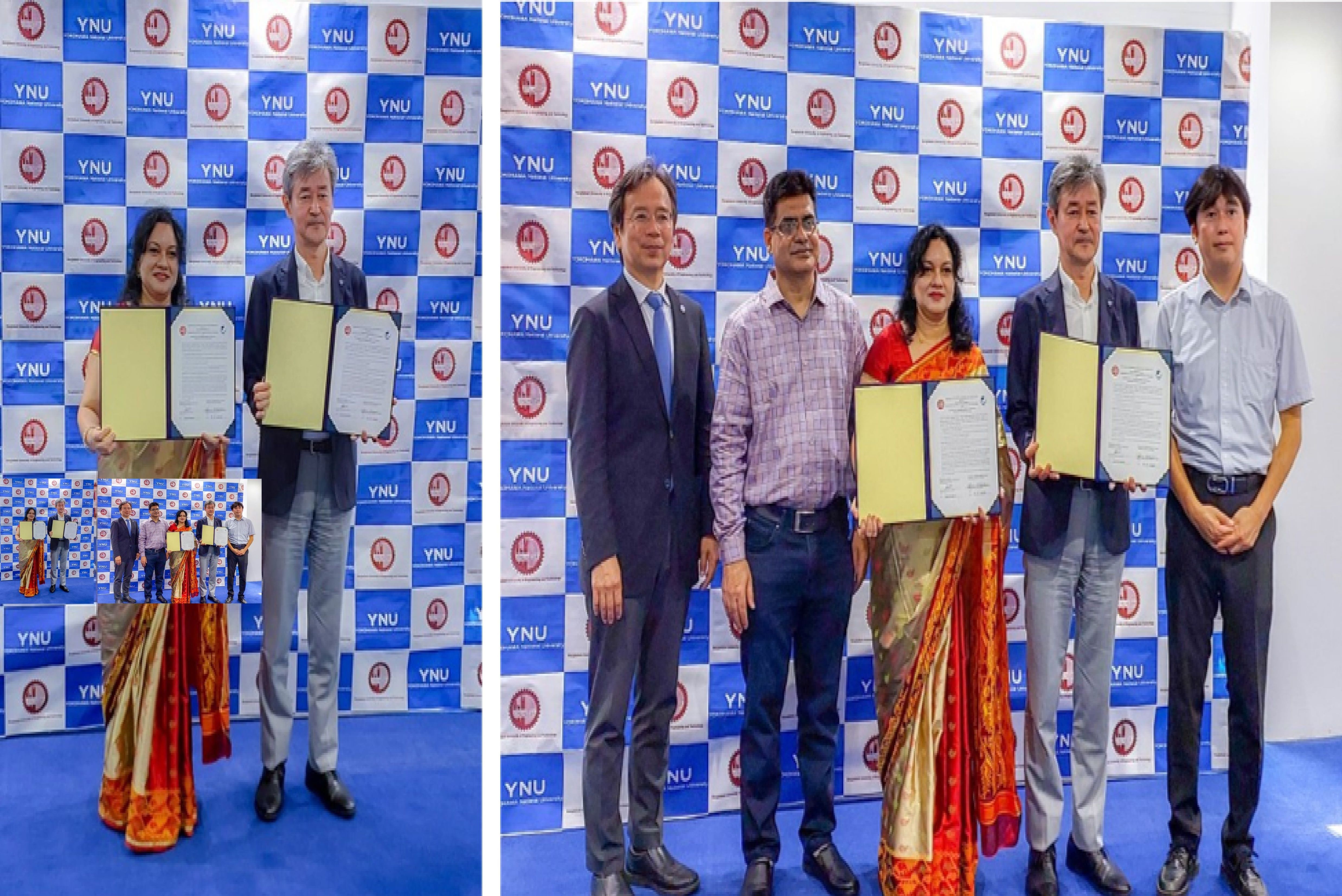
On 04 July 2024, a signing ceremony was held at the office of the honorable president of Yokohama National University, Japan, to formalize an agreement and memorandum of understanding (MoU) between the Department of Physics, Bangladesh University of Engineering and Technology (BUET), Bangladesh and the Typhoon Science and Technology Research Center (TRC), Institute for Multidisciplinary Sciences, Yokohama National University, Japan. The TRC, Japan's first specialized typhoon research institute, aims to contribute to the creation of a safe, sustainable, and vibrant society by reducing the risk of typhoon/cyclone disasters and contributing to the realization of a decarbonized society through the use of typhoon/cyclone energy.
The ceremony was graced by the honorable president and Dean, Prof. Umehara Izuru, Yokohama National University, who signed the agreement. The agreement encompasses the exchange and visits of graduate students, non-teaching staff, post-graduate fellows, and faculty members. It also includes the exchange of information and materials in mutually interesting fields, the organization of joint conferences and academic programs, and collaboration on joint research activities and publications.
Director Prof. Hironori Fudeyasu and Vice Director Prof. Kazuhisa Tsuboki from the TRC as well as Prof. Md. Rafi Uddin and Prof. Nasreen Akter from Department of Physics, BUET were present in the signing program. Notably, Prof. Dr. Nasreen Akter signed the Agreement/MoU as the focal person.
Signing Ceremony of the Agreement on Academic Exchange and Memorandum of Understanding between Yokohama National University, Japan, and BUET:-1
Research Summary
It is well known that Bangladesh is one of the most vulnerable countries due to extreme weather events (such as cyclones, tornadoes, floods, droughts, heavy rain, lightning, etc) and climate change. Since these extreme weather events cause loss of life and property, it is crucial to understand what impact may have on their occurrence. However, these extreme weather events in Bangladesh are poorly understood due to a lack of meteorological research and data. I am using radar, satellites, numerical models, and other observational data to study extreme weather events and their impact on Bangladesh. Currently, I am working in the fields of Mesoscale Meteorology, Radar Meteorology, Monsoon Meteorology, Mesoscale Modeling, Lightning, and Climate Change.
RESEARCH COLLABORATIONS:
1. Collaboration with Typhoon Science and Technology Research Center (TRC), Yokohama National University, Japan. [Press Release ]
2. Collaboration with Kagawa University, Japan.
3. Collaboration for observation on Lightning Detection in Bangladesh and surrounding regions with the Shonan Institute of Technology, Japan.
4. Collaboration with Kochi University, Japan.
5. Collaboration with the Institute for Space-Earth Environmental Research (ISEE), Nagoya University, Japan.
6. Collaboration with Curtin University, Australia.
GRANTS FOR ATTENDING CONFERENCES, WORKSHOPS AND TRAINING:
1. Grants for the 11th Workshop of International Precipitation Working Group (IPWG-11), 15-18 July 2024, Tokyo Institute of Technology, Tokyo, Japan, 2024.
2. Grants for the 9th Global Energy and Water Exchanges Open Science Conference (GEWEX OSC), 07-12 July 2024, Sapporo, Japan, 2024.
3. Grants for new and emerging remote sensing technologies for precipitation data sets and their applications and validation, Organized by the International Precipitation Working Group (IPWG) and Japan Aerospace Exploration Agency (JAXA), 17-19 November 2014, Tsukuba, Japan.
4. Grants for the Monsoon Asia Integrated Regional Studies (MAIRS) Open Science Conference (MAIRS-OSC2014), 07-10 April 2014, Beijing, China, 2014.
5. Grants for the 2nd International Conference on Southeast Asian Weather and Climate (ICSA-WC2013), 27-29 November 2013, Chiang Mai, Thailand, 2013. [From BUET]
6. Grants for the 5th International Workshop on Monsoons (IWM-V), 28 October - 01 November 2013, Macao, China, 2013.
7. Grants for the 34th Asian Conference on Remote Sensing (ACRS-2013), 20 -24 October 2013, Bali Island, Indonesia, 2013.
8. Grants for INEES Final Workshop, Organized by the University of Flensburg and International Network for Energy & Environmental Sustainability (INEES), University of Flensburg, 19-23 August 2013, Flensburg, Germany.
9. Grants for the 4th TRMM and GPM International Science Conference, 13-16 November 2012, Tokyo, Japan, 2012.
10. Grants for INEES Science Education-III, Organized by the University of Flensburg and International Network for Energy & Environmental Sustainability (INEES), University of Flensburg, 13-17 February 2012, Flensburg, Germany.
11. Grants for the 3rd GPM Asia Workshop on Precipitation Data Application Technique, Tokyo, Japan, December 7, 2011.
12. Grants for International Conference on Environment Science and Engineering (ICESE 2011), Bali Island, Indonesia, 1-3 April, 2011. [From BUET]
13. Grants for INEES Science Education, Organized by the University of the West Indies and International Network for Energy & Environmental Sustainability (INEES), University of Flensburg, 03-09 October 2010, Jamaica.
14. Grants for Autumn Meeting of the Meteorological Society of Japan, 19-21 November 2008, Sendai, Japan.
15. Grants for Satellite Remote Sensing of Atmospheric Constituents, Organized by Water Science Unit of UNESCO Office Jakarta and the Institute of Hydrospheric Atmospheric Sciences of Nagoya University, 3-15 November 2008, Nagoya, Japan.
16. Grants for the 6th International Conference on Mesoscale Meteorology and Typhoon in East Asia (ICMCS-VI), 6-9 November 2007, Taipei, Taiwan.
17. Grants for Autumn Meeting of the Meteorological Society of Japan, 14-16 October 2007, Sapporo, Japan.
18. Grants for spring Meeting of the Meteorological Society of Japan, 13-16 May 2007, Tokyo, Japan.
19. Grants for Numerical Prediction of High-Impact Weather Systems, Organized by Water Science Unit of UNESCO Office Jakarta and the Institute of Hydrospheric Atmospheric Sciences of Nagoya University, 2-15 December 2007, Nagoya, Japan.
20. Grants for Third ICTP Workshop on the Theory and Use of Regional Climate Models, 29 May - 9 June 2006, ICTP, Trieste, Italy.
21. Grants for 2nd KAGI21 International Summer School, Organized by Faculty of Earth Sciences and Mineral Technology, Institut Teknologi Bandung (FIKTM-ITM) and Kyoto University Active Geosphere Investigations for the 21st Century COE program (KAGI21), 14-27 August 2005, ITB, Bandung, Indonesia.
Interests
- Monsoon Meteorology, Remote Sensing, Mesoscale Modeling, Lightning and Climate Change.
Research Projects
-

Funded by Grant for Advance Research in Education (GARE), BANBEIS, Ministry of Education, Bangladesh
-

Funded by University Grants Commission (UGC), Bangladesh
-

Funded by BUET and JFE Steel Corporation, Japan (Member)
-
Funded by DAAD, Germany through University of Flensburg (Member)
-
Funded by NASDA, Japan through Nagoya University Japan (Member)
-
Project funded by Ministry of Science and Technology, Bangladesh


Contact
Dr. Md. Rafi Uddin
Professor, Department of Physics,
Room No. OAB 109
Old Academic Building (OAB)
Bangladesh University of Engineering and Technology (BUET)
Dhaka-1000, Bangladesh.
E-mail: rafiuddin@phy.buet.ac.bd, rafii015@yahoo.com
webpage: http://rafiuddin.buet.ac.bd/
Tel: +880-2-9665650-80 (Ext. 7151, 7491)