
Bio
Dr. Nasreen Akter
B. Sc. Hons. (DU), M. Sc. (DU), M. Phil. (BUET), Ph. D. (Nagoya University, Japan)
Professor
Research field: Tropical Cyclone, Aerosol, Monsoon, Mesoscale Meteorology and Numerical Modeling.
Prof. Dr. Nasreen Akter was born at Dhaka, Bangladesh in 1973. She has obtained B.Sc. (Honours) in 1995 and M. Sc. in 1999 in Physics from the University of Dhaka. She has completed her M. Phil in Atmospheric Physics in 2007 from Bangladesh University of Engineering and Technology (BUET). She obtained D. Sc. degree in the field of Meteorology from the Department of Earth and Environmental Sciences, Nagoya University, Japan in 2010. Her teaching career commenced at BRAC University, Dhaka as a Lecturer. She served there for 02 years. Thereafter, she joined BUET on 01 December 2004 as a lecturer. She was appointed as Assistant Professor, Associate Professor and Professor in 2007, 2013 and 2016, respectively.
E-mail: nasreenakter@phy.buet.ac.bd, nasreenphysics@gmail.com
Tel: 55167228-57 (Ext. 7317)
For more information: http://nasreenakter.buet.ac.bd
Education & Training
-
Ph. D 2010
Meteorology
Nagoya University, Japan, Title of the dissertation: Numerical study of an outer rainband and its convective cells associated with Cyclone Sidr
-
Master of Philosophy 2007, A grade (GPA 3.92)
Atmospheric Physics
Bangladesh University of Engineering & Technology (BUET), Bangladesh, Title of the dissertation: Sensitivity test of different cumulus parameterizations in MM5 modelling for Bangledesh
-
Master of Science in Physics 1999 (held in 2001), 1st Class (1st Position)
Physics
University of Dhaka, Bangladesh, Title of the dissertation: Development of user-friendly software for acquisition of Spirometric data
-
Bachelor of Science in Physics 1995 (held in 1997), 1st Class (2nd Position)
Physics
University of Dhaka, Bangladesh
Honors, Awards and Grants
-
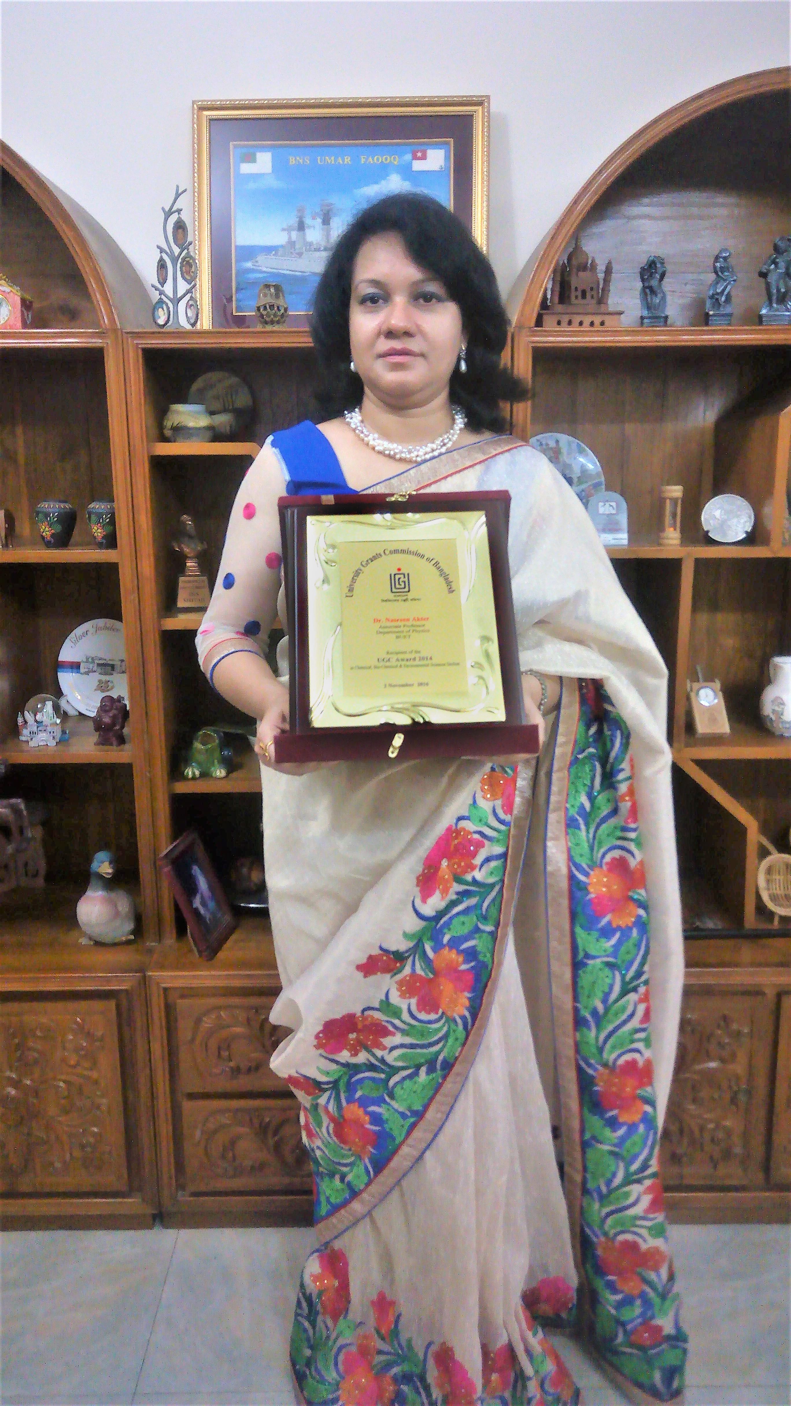
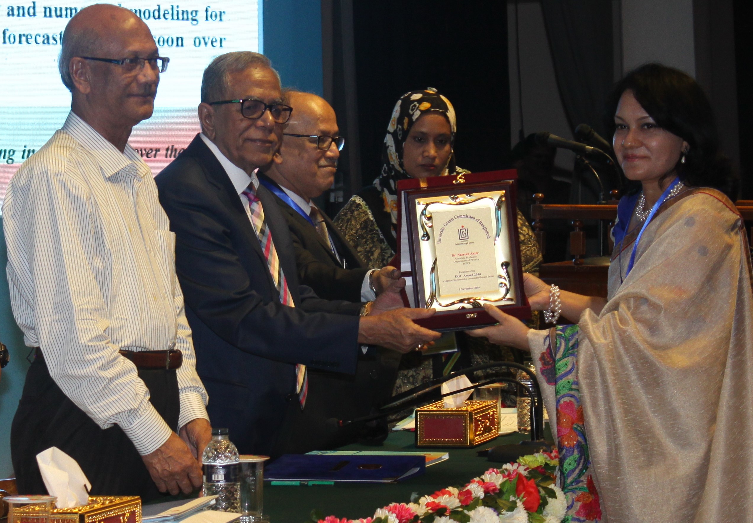
2014UGC Award

Research paper titled "Role of Synoptic-Scale Forcing in Cyclogenesis over the Bay of Bengal"
-
2007-2010Monbukagakusho Scholarship
Ph. D program
-
2001Dhaka University Merit Award
being 1st position in Master of Science
Publications
Filter by type:
Sort by year:
Pre-monsoon lightning in Bangladesh: Separating most from least active days with thermodynamic and synoptic composites
Journal Paper Atmospheric Research, 325:108261, 2025
Abstract
The pre-monsoon season (March–May) in Bangladesh is the most hazardous period for lightning-related human casualties, particularly during morning and afternoon hours. This heightened risk is primarily associated with labor-intensive manual agriculture on smallholder farms. This study investigates the atmospheric conditions corresponding to the 50 most active and 50 least active pre-monsoon lightning days between 2015 and 2020. Analysis of sounding and reanalysis data reveals distinct differences across nearly all dynamic, thermodynamic, surface, and upper-air composite parameters. On the most active lightning days, the environment typically features a SWEAT index exceeding 230, a mixed-layer mixing ratio above 15 g kg−1, and high values of the most unstable convective available potential energy (≥1580 J kg−1), along with elevated instability—all conducive to thunderstorms with heavy rainfall. Notably, on 20 % of these active days, storm-relative environmental helicity reaches between 300 and 485 m2 s−2, indicating a high potential for supercell thunderstorms and intense lightning activity. In contrast, the least-active lightning days are characterized by weaker storm systems. These variations are primarily driven by strong, warm, moist southwesterly winds from the Bay of Bengal, which enhance horizontal temperature gradients and atmospheric instability. Regression models identified potential instability, cloud ice water content, and cloud liquid water content as strong synoptic-scale predictors of lightning activity. Principal component analysis (PCA) further highlighted the critical role of cloud-scale thermodynamic and kinematic variables in distinguishing lightning intensity. These findings provide a foundation for developing daily lightning forecast systems, with potential benefits for public safety and protection of lightning-sensitive infrastructure.
Role of pollutants on the bimodal lightning distribution in Bangladesh
Journal Paper Earth Systems and Environment
Abstract
The impact of atmospheric pollutants on lightning activity is an evolving issue. This study investigates the relationship between various pollutants and lightning occurrences in Bangladesh, a country that is frequently affected by extreme weather events. Using six years of cloud-to-ground lightning records (2015–2020) from Vaisala’s Global Lightning Dataset and pollutants data, including aerosols, particulate matter (PM1, PM2.5, and PM10), and other compounds from the ECMWF Atmospheric Composition Reanalysis 4, the study explores interactions between lightning and pollutions in detail. Over the study period, 754 lightning days and 1,438 non-lightning days were documented, with the highest stroke count of 817,547, observed on 5 April 2016. Lightning activity exhibited a bimodal distribution, with the primary peak in April-May and a secondary peak in August-September. The winter months (December-January) experienced the least lightning activity. The highest concentrations of DUST, SO4, and O3 coincided with the primary peak, revealing significant positive correlations (r = 0.7, 0.6, and 0.6, respectively) at the 99% confidence level. In contrast, PM1, PM2.5, and PM10 concentrations peaked in winter and showed moderately negative correlations (- 0.5) with lightning. A comparative analysis reveals that DUST and SO4 concentrations during the primary lightning peak were 88% and 51% higher than in the secondary peak. These findings suggest that the transportation of large amounts of DUST and SO4 by strong upper-level westerlies in April-May, and smaller amounts by low-level southwesterlies in August-September, significantly influences the observed bimodal distribution of lightning activity in Bangladesh, potentially through modifications in thundercloud dynamics.
Outbreak of a Tornado with Tropical Cyclone Yaas (2021) Formed over the Bay of Bengal
Journal Paper Asia-Pacific Journal of Atmospheric Sciences
Abstract
A tornado outbreak occurred in West Bengal (WB), India, about 15–16 h before the landfall of Cyclone Yaas formed in May 2021 over the Bay of Bengal. High-resolution analysis data have been used to investigate the possible tornadoes in terms of environmental conditions connecting to the cyclone. The WB tornado is found as intense as EF2–3 on the tornado scale and is likely associated with a mini-supercell. The total shear of 37 m s−1 from 0–6 km above ground level (AGL) with strong clockwise rotation, the moderate instability (1504 J kg−1) and the energy helicity index of 2.2 are the substantial convective parameters related to the WB tornado. Moreover, the favorable environment owning intense bulk shear, a larger value of storm-relative environmental helicity in the lowest 1 km AGL and high values of significant tornado parameter (STP) urge the potentiality of multiple tornadoes spawning in multi-days accompanying the landfalling Cyclone Yaas. The right-front quadrant of the cyclone is found to be more vulnerable for developing moderate to severe tornadoes within its rainbands. The positive potential vorticity anomalies evidence the cloud-scale cyclonic circulation from surface to 400 hPa with the maximum in the mid-level.
Tropical cyclogenesis associated with premonsoon climatological dryline over the Bay of Bengal
Journal Paper Natural Hazards, 112, 2625–2647
Abstract
Tropical cyclones of the Bay of Bengal (BoB) that formed near the synoptic-scale dryline usually intensified over a distance of 600-800 km within 3 days and caused severe destruction after landfall. High-resolution simulations of very severe cyclonic storms in association with dryline indicate that the meridional shear aids in the development of a linear-shaped group of convective cells that mature as an east-west oriented quasi-linear convective system (QLCS) within the boundary between the dry-moist air masses. The leading edge deep convections are supported by low-level moist southwesterly inflow; however, the typical mid-level mesoscale convective vortex (MCV) associated with these QLCS is unremarkable due to a very narrow trailing stratiform region within the QLCS. Supercells are likely to be organized within the QLCS due to extremely unstable atmospheric conditions resulting from a strong vertical shear of 27-39 m s−1 between 0-6 km and large convective available potential energy of >3000 J kg−1. The vertical shear veering with height causes several numbers of low-level mesovortices having diameters less than 10 km at the leading edge in the different convective stages of the QLCS. The dryline aloft in the BoB produces horizontal positive shear vorticity of the order 10–5 s−1 with higher values in the levels 850-600 hPa. The advection of intense cloud-scale cyclonic mesovortices (~10–3 s−1) assists and enhances a cyclonic vortex to the rear side of the QLCS that performs as an MCV for cyclogenesis over the BoB.
Recurvature and movement processes of tropical cyclones over the Bay of Bengal. Quarterly Journal of the Royal Meteorological Society
Journal Paper 147, 3681-3702, 2021
Abstract
Active bimodal tropical cyclones (TCs) are embedded in nonuniform flows over the Bay of Bengal (BoB). More than half of the TCs that occurred from 1990-2019 recurved from their original paths due to the influence of 500-300 hPa steering flows. Premonsoon TCs have a tendency to turn right and make landfall on the right-side coastal areas of the BoB. On the other hand, most of the TCs that occurred in the postmonsoon season crossed the left coast or east coast of India even though deviated left or right from their paths. The simulation shows that Cyclone Roanu (2016) was driven by a warm, moist, unstable southwesterly that was blocked and diverted by the hot, dry stable air masses of northerlies and northwesterlies. As a result, the TC moved along the dry-moist boundary, keeping a constant distance of ~400 km between the eye and dryline. Conversely, the combined steering of moist southeasterly and southward-moving upper-level westerly jets controlled the track of postmonsoon Cyclone Madi (2013), encompassing a left turn of ~150°. In addition to the primary steering mechanism, TC vortex propagation can be explained by the strong vertical shear (>30 m.s-1) offered by the dryline during the premonsoon period and near the monsoon trough in the postmonsoon period. This vertical shear causes the upper-level anticyclone to tilt downshear, resulting in the forward motion of the TC vortex. The deep convection and associated mesovortices, especially those more prominent along the dryline, additionally influence asymmetric diabatic heating, contributing to the advection of TC potential vorticity.
Variability of Low-Level Moisture Flux and Its Relation With Precipitation
Journal Paper The Atmosphere, 7(1), 39-46, 2017
Abstract
This study investigates long-term variation of low-level vertically integrated moisture flux (VIMF) from 1000 hPa to 850 hPa for 37-year from 1979 to 2015 and its contributions to the total rainfall over South Asia (SA), which includes also the Bay of Bengal and the eastern part of Arabian Sea. ERA-Interim 6-hourly reanalysis data generated by European Centre for Medium-Range Weather Forecasts (ECMWF) having horizontal resolution of approximately 80 km are used in this study. The details of spatial and temporal characteristics of low-level moisture flux and its effect on precipitation are analyzed for the sub-regions of South-West (SW), Bay of Bengal (BoB), South-East (SE), North-West (NW), Bangladesh and surroundings (BAN), and North-East (NE). The average value of 37 years VIMF over the study area is found 113.71 kg m-1 s-1, which remains almost constant over the year. About 41% of the total VIMF is found to be advected in the monsoon season, whereas, in the winter season only 17% is transported. The value of VIMF is highest (191.74 kg m-1 s-1) in July over SA which is 33% more than the minimum value in March. For six sub-domains, 27% of the total VIMF is found over the BoB whereas only 6% is found over the NE domain. The SW, SE, NW and BAN regions receive 21%, 19%, 13% and 14% of the total flux, respectively. Southern part of the study area (SW, BoB and SE) acquires 67% of the total VIMF, whereas, 33% is found over the Northern part (NW, BAN and NE). Seasonal variation indicates that the Southern parts of the study area have two times higher VIMF than the Northern parts in the monsoon season. Low level moisture flux contributes large amount of precipitation over the study area. 72% of total precipitation is coming from moisture transport whereas only 28% contributes from local evaporation. Individual domains also show the similar contributions. The coefficient of determination (correlation coefficient) between VIMF and the advective component of precipitation is 0.87 (0.96) and that for evaporation and the precipitation arising from local evaporation (Pm) is 0.456 (0.85).
An Overview of Tropical Cyclone Formation over the Bay of Bengal
Journal Paper Bangladesh Maritime Journal, Vol 1, 99-111, 2017
Abstract
Tropical Cyclone is characterized by a warm-core low pressure system at the centre called eye. It is often accompanied with strong gusty winds, torrential rains and storm surges which create great damage to life and property. The outer rain bands of the eye are made up of convective cells embedded in straight form rain. Thehorizontal shape of an outer rain band is generally prominent with equiangular spiral geometry but in the Bay of Bengal the eastern side band of the cyclone Sidr (2007) was a long, quasi-straight shape in the meridional direction that remained stationary relative to the cyclone centre. In fact, the Bay of Bengal experiences many differences in forming tropical cyclone. The formation of TC is bimodal and the post-monsoon cyclone frequency is almost double than that of pre-monsoon cyclone. Again, pre-monsoonenvironments are more favourable for cyclogenesis. So, it is very important to improve the understanding of the cyclone characteristics and monitor their intensity in the Bay of Bengal.
Climatology of the Premonsoon Indian Dryline
Abstract
A northeast‐ to southwest‐oriented surface dryline with a dew point gradient of 1 °C per 10 km develops along the eastern Indian coast during the entire premonsoon season. Deep, hot, dry air of up to 500 hPa moves from arid regions in Southwest Asia and Western India to the Bay of Bengal (BoB), and warm, shallow, moist air from the BoB penetrates below the dry air, forming an inclined moisture gradient aloft to the east and reaching the surface to the west. The slope of the gradient depends on the vertically increased southwesterly wind over the BoB, which gradually intensifies from March to May. Diurnal low‐level temperature variations over the land cause periodic movements of the dry‐moist air convergence zone at the surface in the zonal direction. During the premonsoon, the average east–west diurnal oscillation of the surface dryline is approximately 100 km, and the eastward movement is almost three times faster than the westward movement.
The Effect of Atmospheric Variables on Soil Moisture over Bangladesh
Journal Paper The Atmosphere, Vol 6(1), 58-63, 2016
Abstract
The moisture for four different depths of soil is analyzed using 36-years reanalysis data. The spatial variation shows that moisture increases with the soil depth. This characteristic is prominent in the dry season (November-May), whereas in the wet season (June-October) moisture reaches the saturated conditions for all layers. The value of soil moisture provides an annual periodicity with maximum value of 0.28 m3m-3 in July and minimum value of 0.17 m3m-3 in March. Atmospheric variables of evaporation minus precipitation and relative humidity are compared to soil moisture in the surface layer which indicates the strong positive relation with the correlation coefficient value of -0.87 and 0.88, respectively. Monthly temperature variation also affects on the amount of soil moisture. The changing of surface temperature changes soil moisture after two months later with an approximate value of 0.01 m3m-3.The long-term annual variability of soil moisture provides a periodic trend for all layers which indicates about the effect of climate change.
The Variation of Sea Salt Aerosol over North Indian Ocean Including Bangladesh and Its Impact
Journal Paper The Atmosphere, 6(1), 84-89, 2016
Abstract
Aerosols are the severe threats to human life as well as ecosystem. Highest amount of natural and anthropogenic aerosols are observed over the South Asian region. Among the natural aerosols, sea salt aerosols (SSAs) have significant concentrations which are analyzed using the Monitoring Atmospheric Composition & Climate (MACC) reanalysis data for 10 years from 2003 to 2012. Average SSA is found to be about 17% of the total aerosols over the North Indian Ocean (NIO). On the other hand, Bangladesh receives 9% SSAs which are mostly advected by the southerly wind from the Ocean. The annual variations of SSA are found to be significantly positive with an approximate value of 19% in the NIO and 28% in Bangladesh. Seasonal distributions of SSA provide a highest concentration of 0.13 during the monsoon season (June-September) and lowest value of 0.03 in winter (January-February). The average wind velocity over the NIO has displayed strong positive correlation with SSA (r = ~0.93), which plays the major role for the seasonal variability of SSA distribution. The monthly average precipitation and relative humidity at surface are positively correlated with SSA by the values of 0.83 and 0.70, respectively for the NIO.
Mesoscale Convection and Bimodal Cyclogenesis over the Bay of Bengal
Journal Paper Monthly Weather Review,143, 3495-3517, 2015
Abstract
Mesoscale convective systems (MCSs) are an essential component of cyclogenesis, and their structure and characteristics determine the intensity and severity of associated cyclones. Case studies were performed by simulating tropical cyclones that formed during the pre- and postmonsoon periods in 2007 and 2010 over the Bay of Bengal (BoB). The pre- (post) monsoon environment was characterized by the coupling of northwesterly (southwesterly) wind to the early advance southwesterly (northeasterly) monsoonal wind in the BoB. The surges of low-level warm southwesterlies with clockwise-rotating vertical shear in the premonsoon period and moderately cool northeasterlies with anticlockwise-rotating vertical shear in the postmonsoon period transported moisture and triggered MCSs within preexisting disturbances near the monsoon trough over the BoB. Mature MCSs associated with bimodal cyclone formations were quasi linear, and they featured leading-edge deep convection and a trailing stratiform precipitation region, which was very narrow in the postmonsoon cases.
In the premonsoon cases, the MCSs became severe bow echoes when intense and moist southwesterlies were imposed along the dryline convergence zone in the northern and northwestern BoB. However, the development formed a nonsevere and nonorganized linear system when the convergence zone was farther south of the dryline. In the postmonsoon cases, cyclogenesis was favored by squall-line MCSs with a north–south orientation over the BoB. All convective systems moved quickly, persisted for a long time, and contained suitable environments for developing low-level cyclonic mesovortices at their leading edges, which played an additional role in forming mesoscale convective vortices during cyclogenesis in the BoB.
Role of Synoptic-Scale Forcing in Cyclogenesis over the Bay of Bengal
Journal Paper Climate Dynamics, 43, 2651-2662, 2014
Abstract
The cyclone frequency distribution over the Bay of Bengal during 1990–2009 was distinctly bimodal, with a primary post-monsoon peak and a secondary pre-monsoon peak, despite the very high convective available potential energy (CAPE) during the pre-monsoon. The location of the monsoon trough over the bay is a primary factor in tropical cyclogenesis. Because the trough was in the northernmost bay during the pre-monsoon season, cyclogenesis was inactive in the southern bay, where a strong southwesterly wind shear was found. In this season, moreover, a hot, dry air mass extending vertically from 950 to 600 hPa was advected from northwestern India toward the bay. Moist, warm southwesterly winds penetrating below the deep, dry air mass caused a prominent dryline to form aloft on the northwestern side of the bay. The synoptic-scale hot, dry air forcing to the bay suppressed the active convection necessary for cyclogenesis. The strength of the stable environmental layer, represented by convective inhibition (CIN), was extremely large, and acted as a cap over the northern and northwestern bay. Conversely, during the post-monsoon, there were no horizontal temperature or moisture gradients, and CAPE and CIN were fairly modest. The entire bay was covered by a very deep, moist layer from the surface to 700 hPa transported from the east. The monsoon trough position and the environmental CIN in combination can explain the lower frequency of cyclogenesis during the pre-monsoon compared with the post-monsoon season.
Numerical Simulation of Cyclone Sidr Using Cloud Resolving Model: Characteristics and Formation Process of an Outer Rainband
Journal Paper Monthly Weather Review,140,789-810, 2012
Abstract
Cyclone Sidr, one of the most devastating tropical cyclones that resulted in several thousand deaths and substantial damages, developed in the north Indian Ocean and made landfall over the Bangladesh coast on 15 November 2007. Observation and simulation results show that Sidr was embedded in a nonuniform environment and contained an intense outer rainband to the east of its center and a significant frontal band to the northwest. A detailed study of the outer rainband is performed by numerical simulation.
The eastern band was a long, quasi-straight shape in the meridional direction that remained stationary relative to the cyclone center. This band was composed of convective cells that developed southeast of the center within a synoptic-scale convergence zone and propagated along the band toward the northeast quadrant. The speed of the downwind-propagating cells was greater than that of the cyclone, which resulted in a convective cluster northeast of the center. Only the downwind portion of the band consisted of convection with stratiform rain, whereas the upwind and middle portions contained active convective cells without stratiform rain.
The band was located between the synoptic-scale flows of a weakly sheared, gradient-balanced westerly and a strongly sheared, nongradient-balanced prevailing southerly caused by the complex terrain of the Bay of Bengal’s southeast region. Low-level convergence along the band was dominated by cross-band flow from both sides of the band and was confined below 3 km. As the cyclone moved northward, the convergence zone resulted in the extension of band length up to ~800 km. The southerly at the eastern side of the center gradually accelerated and was directed toward the center by a strong pressure gradient force. The flow accumulated a substantial amount of water vapor from the sea in addition to the increased moisture in the lower troposphere, resulting in further intensification of the convective cells.
Characteristics of Supercells in the Rainband of Numerically Simulated Cyclone Sidr
Journal Paper SOLA, 6A, 25-28, 2010
Abstract
Cyclone Sidr had an intense rainband east of the cyclone center. The rainband exhibited two strong convective lines (band axes) composed of convective cells. To study the characteristics of the convective cells, a simulation was performed at 1-km resolu-tion by using a cloud-resolving model. In both band axes, some cells showed the characteristic structure of a supercell. Supercells within the outer axis had stronger updraft, more intense precipita-tion, and a longer lifetime than those of the inner axis. The values of the CAPE and helicity are different in the strong vertical shear environment of the inner and outer axes. A large moisture flux was present throughout the troposphere on the east side of the outer axis. On the other hand, the upper level west of the inner axis was relatively dry. These are additional factors affecting the differ-ences in cell characteristics in the two band axes.
Employment of MM5 in Simulating MCSs Developed in and around Bangladesh
Journal Paper Mausam, 60(2), 137-146, 2009
Abstract
The mesoscale convective systems (MCSs) produce numerous weather hazards with their variety of form. The formation mechanism of MCSs is thus important to know for Bangladesh and its surroundings, because this region is one of the heaviest rainfall areas in the tropical zone. The meteorologists are studying and analysing the formation mechanism of different types of MCSs using radar and satellite observations data. There are limitations to acquire the continuous data from weather radar and rain-gauge network in Bangladesh. Observations are limited to real time, but for planning purposes projected data over a certain period obtained from a climate model is the requirement. Consequently the motivation of this paper is to obtain the evolution and life cycle of MCSs developed in and around Bangladesh in pre-monsoon period on 20 May 2002 using the simulation data from numerical mesoscale model called MM5. Before going to use the model data in application purposes the calibration of MM5 model for cumulus parameterization has been performed during the pre-monsoon period for this region. In the present study two domains with mesh resolutions 45 × 45 km and 15 × 15 km are prepared. Five MM5 runs using different cumulus parameterizations are carried out for sensitivity test. For that purpose the precipitations data of the model are compared structurally and numerically with that of tropical rainfall measuring mission (TRMM) data products, available data from radar scan and observed rain-gauges in Bangladesh. Important features like lifetime, maintenance mechanism, traversed path, propagation speed and direction of MCSs developed in pre-monsoon period in and around Bangladesh could have been pointed out.
Use of MM5 model for wheather forecasting over Bangladesh region
Journal Paper BRAC University Journal, IV(1), 75-79, 2007
Abstract
The severity of weather appears almost every year in Bangladesh. It causes damage of property and takes a very high death toll due to absence of timely and proper forecasting facility. Thus the focus of this paper is to demonstrate the usefulness of weather model for forecasting and estimating convective system. A high resolution mesoscale model MM5 has been used in this regard to observe the accurate rainfall estimation over Bangladesh. The model is run at two nested domains at 45 km and 15 km resolutions for two durations i.e. 31 March to 05 April 2002 and 20 to 25 May 2002. In both the cases, results indicate that the MM5 model has a good capability to estimate rainfall over Bangladesh.
Selection of parameterization in MM5 for the estimation of rainfall in Bangladesh
Journal Paper Bangladesh Journal of Physics, 3, 75-84, 2007
Abstract
Bangladesh is one of the regions of heaviest rainfall in the world. But Bangladesh Meteorological
Department (BMD) is having only s-band weather radar to collect data for one hour with two hours pause to
save the cost of magnetron. Such type of break of data collection is great hindrance to study the convective
systems developed here. Also the surface rain-gauges are very limited in number. In this circumstance, nonhydrostatic
mesoscale model MM5 would be a good tool for the estimation of precipitation in Bangladesh
area once its sensitivity is known to the concerned. With a view to estimate the rainfall in a better manner, a
comparison of rain-gauge data and TRMM 3B42RT products with the outputs of ten MM5 model options has
been conducted for the duration of 138 hours from 20 to 25 May 2002. By this way, the suitable
parameterization scheme of MM5 for the simulation of rainfall in Bangladesh is investigated as a case study.
The simulated rainfall pattern from MM5 nearly agrees with the ground-based observational data. However,
different MM5 options demonstrate some variations in different observation methods as well as domains. For
coarse resolution (45 × 45 km mesh) Anthes-Kuo (Ku) cumulus scheme with Blackadar planetary boundary
layer (PBL) and for nested domain mesh resolutions 15 × 15 km2 and 5 × 5 km2 Ku and Grell cumulus
schemes with MRF PBL respectively are found better with respect to TRMM value.
Retrieval of rain rate from the rain status of BMD radar
Journal Paper The Atmosphere, 3, 24-30, 2007
Abstract
The climate of Bangladesh is characterised by high temperature, heavy rainfall, often excessive humidity, and fairly marked seasonal variations. One of the conventional methods of monitoring the meteorological variable rainfall in Bangladesh is radar installed by the Bangladesh Metrological Department (BMD).The BMD S-band radar measures the reflectivity to provide an estimation of precipitation intensity and displays in six rain statuses. This paper presents a method for retrieving the unknown rain rate out of the six rain statuses from the radar plan position indicator (PPI) scan. The technique has been developed to sample the PPI radar scan into 10 km x 10 km grid boxes having 16 pixels with 2.5 km mesh and assemble the data for each status by rain rate retrieval algorithm. A statistical method has also been proposed to retrieve the rain rate at any particular location within radar coverage. Two cases of year 2003 have been analyzed in two distinct periods i.e. pre-monsoon and monsoon for retrieving the rain rates from the rain status. The result from the retrieval method has been tested through a comparison made between the retrieval rain rate measured from BMD radar and the same obtained from the Tropical Rainfall Measuring Mission (TRMM) PR (precipitation radar).
Interfacing Arrangement and Software Development for Acquisition and Analysis of Respiratory Data
Journal Paper BRAC University Journal, 1, 99-107, 2004
Abstract
Lung diseases are still major killers in Bangladesh due to absence of proper diagnostic equipment primarily because of high cost. Indigenous development of transducer, hardware interface and application software can bring the benefit of modern technology at the doorstep of the people. In this respect, computerisation of a mechanical spirometer is an attempt to make the dream of poor people into reality. A wedge bellow type spirometer as transducer, modified ISA card circuit with low cost arrangement for hardware interface and window based easy operating software have been developed to reach to the target.
Numerical study of mesoscale convective systems for recurving cyclone Madi and non-curving cyclone Phailin formed over the Bay of Bengal in 2013 using WRF model
Conference Paper IYSC, Nepal, 182-192, 2019
Abstract
A mesoscale convective system (MCS) is nothing but a cloud system which occurs in relation with an ensemble of thunderstorms. For tropical cyclone (TC) genesis, MCSs are the basic precursors. In this study, cyclone Phailin and Madi formed over the Bay of Bengal in 2013 are considered to simulate and analyze the characteristics of convective cells and their MCSs using WRF model. Cyclone Madi was a very severe cyclonic storm with maximum wind speed of 85 knots and during life time it changed its direction to the angle of almost 140 degrees from its original track, whereas, cyclone Phailin had maximum wind speed of 140 knots and its direction is almost straight during its lifetime. High unidirectional shear and moderate convective available potential energy (CAPE) suggests the possibility of supercell formation in the rainband of Madi whereas moderate CAPE and small shear are favorable for the development of ordinary convective cells in Phailin. At the mature stage of convective cells, the average length is ~30 km for both TCs and average speed is almost 9 ms-1. The average lifetime of the cells in Madi (Phailin) has been found 3.5 (4.6) hours. The vortex pair within the cells indicates the existence of mesovortices, which is more intense in case of Madi than
Phailin. Intense MCSs having maximum reflectivity >50 dBZ are found in the northern side of Madi and southwest side for Phailin. MCS length (height) before 1 hr of recurving of Madi is approximately 220 (9.8) km, which is reduced to ~180 (5.7) km during curving time even though cyclone has highest wind speed at that time. On the other hand, the MCS length (height) is found 275 (8.5) km for Phailin which remains almost constant. The low-level moisture flux inflow causes the variability of the MCS structure.
Keywords: Tropical cyclone, Raindband, Mesoscale convective system
Recent Posts
-
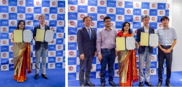
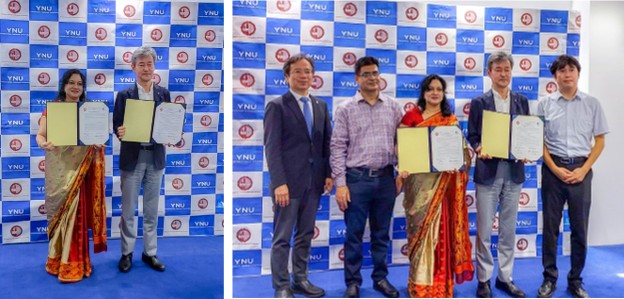
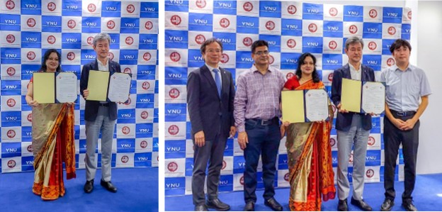
On 04 July 2024, a signing ceremony was held at the office of the honorable president of Yokohama National University, Japan, to formalize an agreement and memorandum of understanding (MoU) between the Department of Physics, Bangladesh University of Engineering and Technology (BUET), Bangladesh and the Typhoon Science and Technology Research Center (TRC), Institute for Multidisciplinary Sciences, Yokohama National University, Japan. The TRC, Japan's first specialized typhoon research institute, aims to contribute to the creation of a safe, sustainable, and vibrant society by reducing the risk of typhoon/cyclone disasters and contributing to the realization of a decarbonized society through the use of typhoon/cyclone energy.
The ceremony was graced by the honorable president and Dean, Prof. Umehara Izuru, Yokohama National University, who signed the agreement. The agreement encompasses the exchange and visits of graduate students, non-teaching staff, post-graduate fellows, and faculty members. It also includes the exchange of information and materials in mutually interesting fields, the organization of joint conferences and academic programs, and collaboration on joint research activities and publications.
Director Prof. Hironori Fudeyasu and Vice Director Prof. Kazuhisa Tsuboki from the TRC as well as Prof. Md. Rafi Uddin and Prof. Nasreen Akter from Department of Physics, BUET were present in the signing program. Notably, Prof. Dr. Nasreen Akter signed the Agreement/MoU as the focal person.
The Agreement on Academic Exchange and Memorandum of Understanding between Yokohama National University, Japan, and BUET-1
Research Summary
Agreement on Scholarly Exchange and Collaboration from July 2024
Department of Physics, Bangladesh University of Engineering and Technology (BUET) (located in Old Academic Building, BUET, Dhaka 1000, Bangladesh) and the Institute for Multidisciplinary Sciences of Yokohama National University (79-5 Tokiwadai, Hodogaya-Ku, Yokohama 240-8501, Japan), desiring to promote cooperation in the fields of education and academic research, agree to the following:
1.1 to encourage exchanges and visits in the following categories: Graduate students, non-teaching staff and post-graduate fellows, and faculty members.
1.2 to exchange information and materials in those fields which are of interest to both universities.
1.3 to organize joint conferences and academic programs.
1.4 to arrange joint research activities and publications.
Research Collaborations:
- Collaboration with Typhoon Science and Technology Research Center (TRC), Yokohama National University, Japan since 202
- Collaboration with Kagawa University, Japan since 201
- Collaboration for observation on Lightning Detection in Bangladesh and surrounding regions with Shonan Institute of Technology, Department of Electrical and Electronic Engineering, Japan since 2017
- Collaboration with Kochi University, Japan since 2017
- Collaboration with the Institute for Space-Earth Environmental Research (ISEE), Nagoya University, Japan since 2010
Grant received under MoU:
-
Sourav Bhowmik, M. Sc. Student, has attended the 2nd International Workshop of the Typhoon Science and Technology Research Center, Organized by Typhoon Science and Technology Research Center, Institute for Multidisciplinary Sciences, Yokohama National University, 27th – 28th November, 2024 and presented the paper titled "Climatology of Environmental Criteria for Bimodal Tropical Cyclogenesis over the Bay of Bengal”.
Interests
- Tropical Cyclone & Extreme Weather, Atmospheric Aerosols, Synoptic and Mesoscale Meteorology, Numerical Modeling
Laboratory Personel
the Agreement on Academic Exchange and Memorandum of Understanding between Yokohama National University, Japan, and BUET
On 04 July 2024, a signing ceremony was held at the office of the honorable president of Yokohama National University, Japan, to formalize an agreement and memorandum of understanding (MoU) between the Department of Physics, Bangladesh University of Engineering and Technology (BUET), Bangladesh and the Typhoon Science and Technology Research Center (TRC), Institute for Multidisciplinary Sciences, Yokohama National University, Japan. The TRC, Japan's first specialized typhoon research institute, aims to contribute to the creation of a safe, sustainable, and vibrant society by reducing the risk of typhoon/cyclone disasters and contributing to the realization of a decarbonized society through the use of typhoon/cyclone energy. The ceremony was graced by the honorable president and Dean, Prof. Umehara Izuru, Yokohama National University, who signed the agreement. The agreement encompasses the exchange and visits of graduate students, non-teaching staff, post-graduate fellows, and faculty members. It also includes the exchange of information and materials in mutually interesting fields, the organization of joint conferences and academic programs, and collaboration on joint research activities and publications. Director Prof. Hironori Fudeyasu and Vice Director Prof. Kazuhisa Tsuboki from the TRC as well as Prof. Md. Rafi Uddin and Prof. Nasreen Akter from Department of Physics, BUET were present in the signing program. Notably, Prof. Dr. Nasreen Akter signed the Agreement/MoU as the focal person.
+ FollowResearch Projects
-

2015-16
-
2017-18
-
2018-2021
-
2020-2021
-
Contribute to the creation of a safe, sustainable, and vibrant society by reducing the risk of typhoon/cyclone disasters and contributing to the realization of a decarbonized society through the use of typhoon/cyclone energy.


Contact
Prof. Dr. Nasreen Akter
Department of Physics
Bangladesh University of Engineering and Technology, Dhaka-1000, Bangladesh
Mobile:+8801711265979
Email: nasreenakter@phy.buet.ac.bd, nasreenphysics@yahoo.com
URL: http://nasreenakter.buet.ac.bd